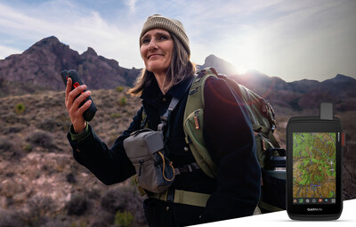
Garmin announces new Montana handheld GPS series with optional SOS satellite communication capabilities to help you stay in touch
Garmin (NYSE: GRMN) has unveiled its new Montana® series of handheld GPS navigators, featuring the Montana 710, 710i, and 760i models. The devices come with 5-inch color touchscreen displays that are glove-friendly and durable, designed for various outdoor activities including hiking and mountain biking.
Key features include preloaded TopoActive maps, worldwide topographical coverage, and multiple mounting options for various vehicles. The 710i and 760i models incorporate inReach® technology for satellite communication capabilities, enabling two-way text messaging and SOS services through the Iridium® satellite network when beyond cellular coverage.
The series offers up to 24 hours of battery life in GPS mode and 440 hours in expedition mode, with IPX7 water resistance rating. The Montana 760i additionally features an 8-megapixel camera with geotagging capabilities. Prices range from $649.99 to $899.99.
Garmin (NYSE: GRMN) ha presentato la sua nuova serie Montana® di navigatori GPS portatili, che include i modelli Montana 710, 710i e 760i. I dispositivi sono dotati di schermi touchscreen a colori da 5 pollici, progettati per essere utilizzabili anche con i guanti e per resistere all'usura, adatti a varie attività all'aperto come escursioni e mountain bike.
Le caratteristiche principali includono mappe TopoActive preinstallate, copertura topografica mondiale e diverse opzioni di montaggio per vari veicoli. I modelli 710i e 760i integrano la tecnologia inReach® per le comunicazioni satellitari, che consente l'invio e la ricezione di messaggi di testo e servizi SOS attraverso la rete satellitare Iridium® quando ci si trova oltre la copertura cellulare.
La serie offre fino a 24 ore di autonomia della batteria in modalità GPS e 440 ore in modalità spedizione, con una classificazione di resistenza all'acqua IPX7. Il Montana 760i presenta inoltre una fotocamera da 8 megapixel con capacità di geotagging. I prezzi variano da $649,99 a $899,99.
Garmin (NYSE: GRMN) ha presentado su nueva serie Montana® de navegadores GPS portátiles, que incluye los modelos Montana 710, 710i y 760i. Los dispositivos cuentan con pantallas táctiles a color de 5 pulgadas que son compatibles con guantes y son duraderas, diseñadas para diversas actividades al aire libre, como senderismo y ciclismo de montaña.
Las características clave incluyen mapas TopoActive preinstalados, cobertura topográfica mundial y múltiples opciones de montaje para varios vehículos. Los modelos 710i y 760i incorporan la tecnología inReach® para capacidades de comunicación por satélite, permitiendo el envío de mensajes de texto y servicios de SOS a través de la red satelital Iridium® cuando se está fuera de cobertura celular.
La serie ofrece hasta 24 horas de duración de la batería en modo GPS y 440 horas en modo de expedición, con una clasificación de resistencia al agua IPX7. El Montana 760i incluye además una cámara de 8 megapíxeles con capacidades de geolocalización. Los precios oscilan entre $649.99 y $899.99.
Garmin (NYSE: GRMN)은 Montana® 시리즈의 휴대용 GPS 내비게이터인 Montana 710, 710i 및 760i 모델을 발표했습니다. 이 기기는 5인치 컬러 터치스크린 디스플레이를 갖추고 있으며, 장갑 착용 시에도 사용할 수 있고 내구성이 뛰어나며 하이킹 및 산악 자전거와 같은 다양한 야외 활동에 적합합니다.
주요 기능으로는 미리 로드된 TopoActive 지도, 전 세계적인 지형 커버리지 및 다양한 차량에 대한 여러 장착 옵션이 포함되어 있습니다. 710i 및 760i 모델은 inReach® 기술을 통합하여 위성 통신 기능을 제공하며, 이동 통신 범위를 넘어설 때 Iridium® 위성 네트워크를 통해 양방향 문자 메시지 전송 및 SOS 서비스를 가능하게 합니다.
이 시리즈는 GPS 모드에서 최대 24시간의 배터리 수명과 원정 모드에서 440시간을 제공합니다. IPX7의 방수 등급을 보유하고 있으며, Montana 760i는 지오태깅 기능을 갖춘 8메가픽셀 카메라도 포함되어 있습니다. 가격은 $649.99에서 $899.99입니다.
Garmin (NYSE: GRMN) a dévoilé sa nouvelle série Montana® de navigateurs GPS portables, comprenant les modèles Montana 710, 710i et 760i. Ces appareils sont équipés de tout-écrans tactiles couleur de 5 pouces qui sont utilisables avec des gants et sont robustes, conçus pour diverses activités de plein air, y compris la randonnée et le VTT.
Les principales caractéristiques incluent des cartes TopoActive préchargées, une couverture topographique mondiale et plusieurs options de montage pour différents véhicules. Les modèles 710i et 760i intègrent la technologie inReach® pour des capacités de communication par satellite, permettant l'envoi et la réception de messages texte ainsi que des services SOS via le réseau satellitaire Iridium® lorsqu'on est hors de la couverture cellulaire.
La série offre jusqu'à 24 heures d'autonomie de la batterie en mode GPS et 440 heures en mode expédition, avec une classification d'étanchéité IPX7. Le Montana 760i dispose en outre d'un appareil photo de 8 mégapixels avec des capacités de géolocalisation. Les prix varient de $649,99 à $899,99.
Garmin (NYSE: GRMN) hat seine neue Montana®-Serie von tragbaren GPS-Navis vorgestellt, zu der die Modelle Montana 710, 710i und 760i gehören. Die Geräte verfügen über 5-Zoll-Farb-Touchscreen-Displays, die sich problemlos mit Handschuhen bedienen lassen und robust sind, und eignen sich hervorragend für verschiedene Outdoor-Aktivitäten wie Wandern und Mountainbiken.
Zu den Hauptmerkmalen gehören vorinstallierte TopoActive-Karten, weltweite topografische Abdeckung und zahlreiche Montagemöglichkeiten für verschiedene Fahrzeuge. Die Modelle 710i und 760i verfügen über inReach®-Technologie für Satellitenkommunikationsmöglichkeiten, die die Verwendung von zweifach Textnachrichten und SOS-Diensten über das Iridium®-Satellitennetzwerk ermöglichen, wenn die Mobilfunkabdeckung nicht verfügbar ist.
Die Serie bietet eine Batterielaufzeit von bis zu 24 Stunden im GPS-Modus und bis zu 440 Stunden im Expeditionsmodus, mit einer IPX7-Wasserbeständigkeitsbewertung. Das Montana 760i verfügt zusätzlich über eine 8-Megapixel-Kamera mit Geotagging-Funktionen. Die Preise liegen zwischen $649,99 und $899,99.
- Launch of new premium GPS product line with prices ranging $649.99-$899.99
- Integration of satellite communication capabilities in 710i and 760i models
- Extended battery life with up to 24 hours in GPS mode
- Expanded revenue potential through optional subscriptions (Outdoor Maps+)
- Higher price point may limit market accessibility
- Requires additional subscription for inReach satellite services
Insights
Garmin's new Montana series represents a strategic expansion in the high-margin outdoor navigation segment. The tiered pricing strategy (<money>$649.99</money> to <money>$899.99</money>) allows market penetration across different consumer segments while maintaining premium positioning. The integration of inReach satellite technology in premium models creates a compelling upsell opportunity and recurring revenue stream through subscription services.
The product's versatility across multiple vehicle types and activities expands the total addressable market significantly. The inclusion of premium features like worldwide TopoActive maps and optional Outdoor Maps+ subscription aligns with Garmin's strategy to generate recurring revenue through software services, moving beyond pure hardware sales.
The technical specifications reveal significant competitive advantages. The multi-GNSS support combining GPS and Galileo networks enhances positioning accuracy in challenging terrains, while the 32 GB storage capacity exceeds industry standards. The IPX7 rating and MIL-STD-810 compliance demonstrate robust engineering, potentially reducing warranty claims and enhancing brand reputation.
The 24-hour GPS mode battery life and extended 440-hour expedition mode are particularly impressive, addressing a critical pain point in outdoor navigation devices. The USB-C charging standard and Wi-Fi connectivity for map updates show forward-thinking design choices that enhance user experience and future-proof the product.
This product launch comes at a strategic time when outdoor recreation continues to see strong growth post-pandemic. The inclusion of satellite SOS capabilities addresses growing safety concerns among outdoor enthusiasts, a feature that commands premium pricing and higher margins. The market for premium outdoor navigation devices is estimated at <money>$2.5 billion</money> globally, with Garmin holding a dominant position.
The subscription-based services (inReach, Outdoor Maps+) align with industry trends toward recurring revenue models, potentially increasing customer lifetime value by <percent>30-40%</percent>. This launch could help maintain Garmin's premium positioning in the outdoor segment, which historically generates higher margins than their automotive division.
Next-gen touchscreen navigators feature a durable design, preloaded worldwide maps and versatility to fit nearly any vehicle
Additionally, the
"No matter your adventure, the new
–Dan Bartel, Garmin Vice President of Global Consumer Sales
Explore confidently
No matter the adventure, the latest
- TopoActive maps: Navigate any adventure with preloaded worldwide topographical maps, optimized for outdoor activities with terrain contours, summits, coastlines and more.
- Satellite imagery: Access high-resolution satellite imagery with direct-to-device downloads over Wi-Fi®. See photorealistic overhead views of routes and surrounding terrain and easily create waypoints based on landmarks.
- Federal Public Land Boundaries: Know the boundaries of public and private land with an optional display overlay on topographic maps to keep the expedition on track.
- City maps: Seamlessly transition from trails to roads with easy-to-follow, turn-by-turn directions using preloaded City Navigator® mapping2.
- Trip planning: Connect with the Garmin Explore™ smartphone app to plan and review trip data, and manage waypoints, courses and activities.
- Outdoor Maps+: Add an Outdoor Maps+ subscription (sold separately) to receive additional premium mapping content, including elevation contours, land boundaries, wildlife areas and more. Easily download regular content updates via Wi-Fi® technology.
- Expanded memory: Download even more maps to suit the journey, such as BlueChart® g3 for reliable navigation on the water (sold separately), with 32 GB of onboard memory.
- Navigation sensors: the next adventure using the built-in sensors, including an altimeter for elevation data, a barometer to monitor the weather and a three-axis electronic compass.
- Multi-GNSS support: Explore with confidence by accessing both GPS and Galileo satellite networks for greater support in more challenging environments.
Rugged by design
Built to handle weather and rugged outdoor conditions, the
Available now, the
Engineered on the inside for life on the outside, Garmin products have revolutionized life for adventurers, athletes, off-road explorers, road warriors and outdoor enthusiasts everywhere. Committed to developing products that enhance experiences, enrich lives and help provide peace of mind, Garmin believes every day is an opportunity to innovate and a chance to beat yesterday. Visit the Garmin Newsroom, email our media team, connect with @garminoutdoor on social, or follow our blog.
1Some jurisdictions regulate or prohibit the use of satellite communication devices. It is the responsibility of the user to know and follow all applicable laws in the jurisdiction where the device is intended to be used.
2City Navigator is available in the
About Garmin: Garmin Ltd. (NYSE: GRMN) is incorporated in
USB-C is a registered trademark of USB Implementers Forum. Wi-Fi is a registered trademark of the Wi-Fi Alliance. All other brands, product names, company names, trademarks and service marks are the properties of their respective owners. All rights reserved.
Notice on Forward-Looking Statements:
This release includes forward-looking statements regarding Garmin Ltd. and its business. Such statements are based on management's current expectations. The forward-looking events and circumstances discussed in this release may not occur and actual results could differ materially as a result of known and unknown risk factors and uncertainties affecting Garmin, including, but not limited to, the risk factors listed in the Annual Report on Form 10-K for the year ended December 30, 2023, filed by Garmin with the Securities and Exchange Commission (Commission file number 0001-411180). A copy of such Form 10-K is available at https://www.garmin.com/en-US/company/investors/earnings/. No forward-looking statement can be guaranteed. Forward-looking statements speak only as of the date on which they are made and Garmin undertakes no obligation to publicly update or revise any forward-looking statement, whether as a result of new information, future events, or otherwise.
MEDIA CONTACTS: Mike Cummings & Adrieanna Norse
913-397-8200
media.relations@garmin.com
View original content to download multimedia:https://www.prnewswire.com/news-releases/garmin-announces-new-montana-handheld-gps-series-with-optional-sos-satellite-communication-capabilities-to-help-you-stay-in-touch-302341918.html
SOURCE Garmin International, Inc.
FAQ
What are the prices of the new Garmin Montana GPS series (GRMN)?
What is the battery life of the new Garmin Montana GPS devices?
Which Montana models feature inReach satellite communication?
What is the screen size of the new Garmin Montana GPS series?