
GreenLight Metals Intersects 30.7m of 1.05% Cu and 1.34 g/t Au (2.49% CuEq1) Including 14.9m of 1.95% Cu and 1.58 g/t Au (3.65% CuEq) at the Bend VMS Deposit in Wisconsin
Rhea-AI Summary
GreenLight Metals (OTCQB: GRLMF) reported assay results from hole B26-007 at the Bend VMS deposit, intersecting 30.7m @ 1.05% Cu, 1.34 g/t Au (2.49% CuEq), including 14.9m @ 1.95% Cu, 1.58 g/t Au (3.65% CuEq). All four Phase 2 holes to date have visual massive to semi-massive sulfides, extending mineralization down-dip and eastward along a ~45-50° plunge.
The permitted Phase 2 program is active (initial 4,000m of a 7,000m program), two rigs are operating, assays for B26-008 to B26-010 are pending, and the company engaged Resource Stock Digest for a US$100,000 marketing program.
Positive
- B26-007: 30.7m @ 1.05% Cu and 1.34 g/t Au (2.49% CuEq)
- Higher-grade core: 14.9m @ 1.95% Cu and 1.58 g/t Au (3.65% CuEq)
- All four Phase 2 holes encountered significant massive to semi-massive sulfides
- Phase 2 drilling active with two rigs; initial 4,000m of a 7,000m permit
Negative
- No metallurgical test work completed; CuEq uses assumed 90% recoveries
- Assays pending for B26-008 through B26-010 (results in 3–6 weeks)
- Drill deviation in holes caused unexpected flattening/steepening affecting planned undercuts
News Market Reaction – GRLMF
In the Apr 27 session, GRLMF gained 16.50%, reflecting a significant positive market reaction.
Data tracked by StockTitan Argus on the day of publication.
AI-generated analysis. How Rhea-AI works. Not financial advice.




Significant visual sulfides encountered in all four holes drilled during the current program
Medford, Wisconsin--(Newsfile Corp. - April 27, 2026) - GreenLight Metals Inc. (TSXV: GRL) (OTCQB: GRLMF) ("GreenLight" or the "Company") is pleased to provide an update on the drilling program at the Bend copper-gold VMS Project in Taylor County, Wisconsin. Assay results from the first hole of the 2026 program (B26-007) have been received and confirm the extension of high-grade copper-gold-tellurium mineralization down-dip from mineralization identified during last year's exploration program. To date, a total of four drillholes (1,909 meters) have been drilled along two sections on the Company's leased forty-acre tract of private minerals with the focus of expanding on mineralization encountered during the previous program. All drillholes have encountered significant visual sulfide mineralization expanding the Bend VMS mineralization down-dip and along strike. Assays for holes B26-008 through B26-010 are expected in the coming weeks.
Highlights
- Phase 2 Program On-Going: The planned initial 4,000m portion of the permitted 7,000m Phase 2 drill program is progressing. The program is building on the strong results of Phase 1, further delineating the VMS-style mineralization down-dip and along strike to the east of the main deposit area. Drilling to date confirms mineralization extends eastward along an approximate 45-50° plunge and extends down-dip of B25-004 by a further approximately 110m. Significant VMS mineralization encountered in these initial drillholes remains open at depth and along trend to the east.
- B26-007: Down-dip extension of mineralization identified from the 2025 drill program (B25-004 - 34.25m of
3.74% copper equivalent ("CuEq")1- 30.7m of
1.05% Copper, 1.34 g/t Gold, 11.49 g/t Silver, and 139 g/t Tellurium (2.49% CuEq) over the entire mineralized section of massive to semi-massive sulfides and interbedded crystal tuff from 330.59m.2 - Including 14.9m of
1.95% Copper, 1.58 g/t Gold, 20.57 g/t Silver, and 227 g/t Tellurium (3.65% CuEq) within the main massive to semi-massive sulfide lens from 338.85m.2
- 30.7m of
- Significant Visual Sulfide Intercepts:
- B26-007: 50.64m (mineralized interval) consisting of multiple massive to semi-massive sulfide lenses and strongly mineralized interbeds/footwall crystal tuff from 320.49m
- B26-008: 52.86m (mineralized interval) consisting of multiple massive to semi-massive sulfide lenses and strongly mineralized interbeds/footwall crystal tuff from 430.6m.
- Including 15.65m of massive to semi-massive sulfide (main lens) from 440.96m
- B26-009: 73.15m (mineralized interval) consisting of strongly mineralized and locally strongly to intensely altered crystal tuff interbedded with multiple semi-massive to massive sulfide lenses ranging from <1m to approximately 8m in thickness from 382.83m. Drilling is ongoing.
- B26-010: 21.06m consisting of massive to semi-massive sulfides interbedded with lesser variably mineralized crystal tuff from 419.71m.
- Expanding Known Zone of Mineralization: All four drillholes drilled during the current exploration program have successfully intercepted significant VMS mineralization, expanding the down-dip extents of the mineralized zone from the previous 2025 drill program and further defining the trend of the deposit's core plunging approximately 45-50 degrees to the east.
Matt Filgate, President & CEO, commented: "Hole B26-007 continues to show continuity in both grade and thickness below hole B25-004, returning 30.7 meters of
Phase 2 Drilling Results and Geological Context
The Phase 2 program continues to test the eastern extensions of the known Bend deposit along two sections with the objectives of expanding the extents of the known mineralization at depth and along strike. All drilling is currently being conducted on the Company's leased Soo Line Railroad forty-acre tract. As previously disclosed, Phase 2 drilling will continue to utilize the allocated meterage to pursue thicker mineralization encountered at depth and along trend to expand the mineralized footprint at the Bend Project.
Stratigraphy across the drill area is consistent, with a sequence of rhyolite to dacite flows overlying interlayered fine ash to lapilli tuffs. Immediately overlying the semi-massive to massive sulfide horizon are laminated exhalative cherty tuffs and argillites ("hanging wall sediments"). The mineralized horizon is underlain by a thick quartz-crystal ("quartz-eye") tuff with strong bedding-parallel pyrite mineralization and pervasive chlorite alteration, followed by a fine-grained chlorite-sericite tuff that marks the unmineralized footwall contact.
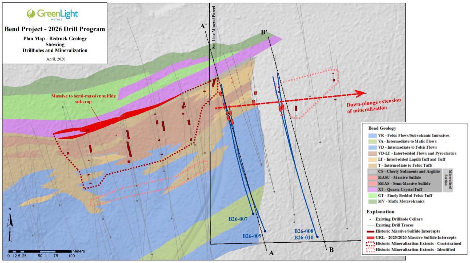
Figure 1: 2026 Drill Program Plan Map
To view an enhanced version of this graphic, please visit:
https://images.newsfilecorp.com/files/7506/294258_glfig14272026.jpg

Figure 2: Generalized Geologic Cross Section A-A'
To view an enhanced version of this graphic, please visit:
https://images.newsfilecorp.com/files/7506/294258_16b8eea264cee909_003full.jpg
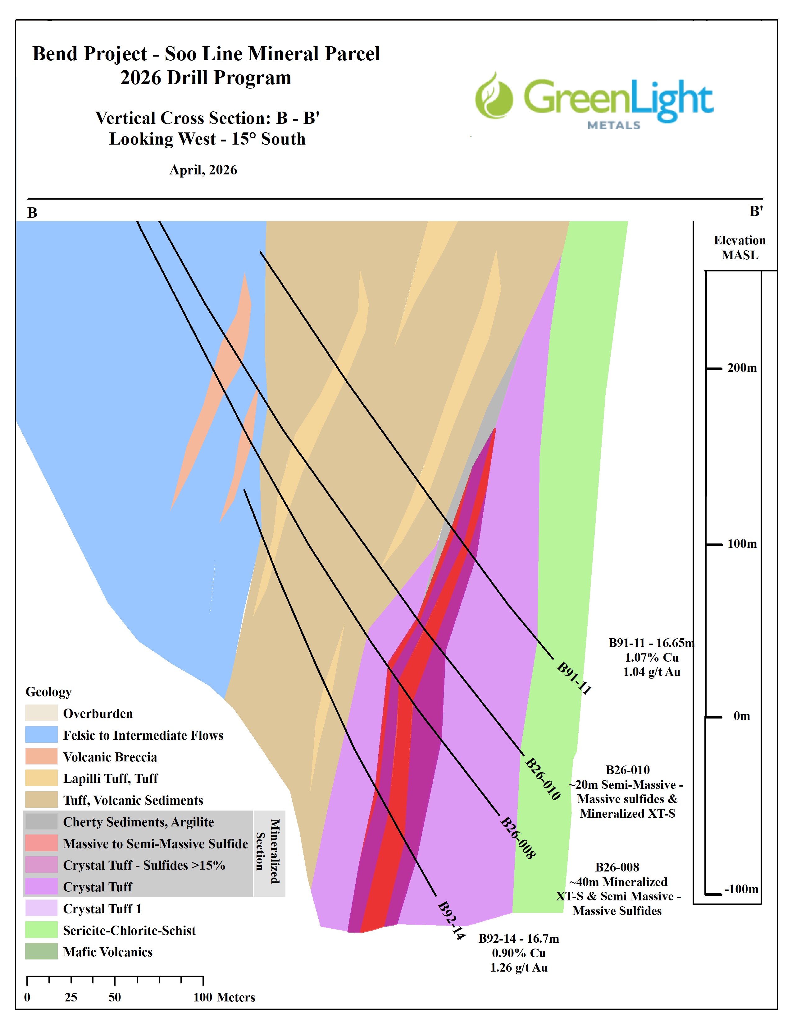
Figure 3: Generalized Geologic Cross Section B-B'
To view an enhanced version of this graphic, please visit:
https://images.newsfilecorp.com/files/7506/294258_16b8eea264cee909_004full.jpg
Table 1: Summary of Significant Intercepts - Hole B26-0072
| DDH | From (m) | To (m) | Interval (m) | Cu (%) | Au (g/t) | Ag (g/t) | Te (g/t) | CuEq (%) |
| B26-007 | 330.59 | 361.29 | 30.70 | 1.05 | 1.34 | 11.49 | 139 | 2.49 |
| Including | 338.85 | 353.75 | 14.90 | 1.95 | 1.58 | 20.57 | 227 | 3.65 |
1Copper Equivalent ("CuEq") is reported to express the aggregate in-situ value of copper, gold and silver as a percentage copper grade. CuEq incorporates assumed metallurgical recoveries and is not a proxy for, nor evidence of, economic value. Tellurium (Te) is reported separately and is not included in CuEq.
CuEq (%) = ((Cu grade (%) / 100 × 0.9 (recovery) × 2204.6 × US
Assumptions: metal prices of US
2The composite grades of select intervals are calculated on a length-weighted basis and are reported as drilled thicknesses. True thicknesses of the intervals are estimated to be 75
Hole Details
B26-007: Designed to undercut the significant semi-massive to massive pyrite-chalcopyrite mineralization intersected in B25-004 (34.25m of
1.35% Cu and 2.22 g/t Au). Unexpected deviation through overburden caused the hole to 'flatten' more than expected. The mineralized horizon was intersected at 320.49m representing an approximate 38m down-dip extension of the mineralized zone.B26-008: Designed to test the variability in mineralization between two, wide-spaced historic intercepts (B91-11 - 16.65m of
1.07% Cu, 1.04 g/t Au and B92-14 - 16.7m of0.9% Cu and 1.26 g/t Au). The mineralized horizon was intersected at 440.96m representing an approximate 75m overcut of B92-14 and showing a thickening of the mineralized section.B26-009: Designed to undercut the mineralized section encountered in B26-007. Unexpected deviation through overburden caused the hole to 'steepen' more than expected. The mineralized horizon was encountered at 382.83m representing an approximate 75m down-dip extension of the mineralized zone (final survey data pending).
B26-010: Designed to test variability and connectivity of mineralization between B26-008 and the wide-spaced historic intercepts (B91-11 - 16.65m of
1.07% Cu, 1.04 g/t Au; B92-14 - 16.7m of0.9% Cu, 1.26 g/t Au). Mineralization was intersected at 419.71m, representing an approximate 45m overcut of B26-008 and an approximate 50m undercut of B91-11 (final survey data pending).
Next Steps
- Pending Assays: Results for visual sulfide intercepts in holes B26-008 through B26-010 expected over the course of the next 3-6 weeks.
- Drilling Ongoing: Continued drilling utilizing two diamond core drill rigs to continue on the Soo Line Mineral tract extending mineralization vertically (90°) down-plunge as well as testing the projected 45°-50° east trending down-plunge extension
Table 2: Drill Collar Information
| Hole ID | Northing (m) | Easting (m) | Elevation (masl) | Azimuth | Dip | Total Depth (m) |
| B26-007 | 5018525 | 688500 | 415.0 | 344 | -65 | 391.97 |
| B26-008 | 5018488 | 688602 | 412.1 | 343 | -66 | 538.58 |
| B26-009 | 5018496 | 688519 | 414.3 | 343 | -67.5 | 455.98 (in progress) |
| B26-010 | 5018488 | 688602 | 412.1 | 343 | -63 | 522.12 |
| Coordinates in NAD83 UTM Zone 15N | ||||||
| Final survey data pending | ||||||
Engagement of Resource Stock Digest for Marketing Services
The Company has entered into a service agreement with Resource Stock Digest ("RSD") dated April 27, 2026 for a two-month advertising and marketing program, including report creation, dissemination and related media buys, for a cash fee of US
RSD is based in Round Rock, Texas and is owned and operated by Gerardo Del Real and Nick Hodge. Of RSD and its principals, only Mr. Hodge owns or controls securities of the Company, consisting of common shares and warrants which, assuming exercise of such warrants, would represent less than
RSD has advised the Company that neither RSD nor Messrs. Del Real and Hodge have participated in any financing of the Company, or otherwise acquired securities of the Company, within the six months preceding the date of the Agreement, and that neither RSD nor Messrs. Del Real and Hodge will subscribe for or otherwise acquire any additional securities of the Company during the term of the Agreement, including through the exercise of warrants, without prior acceptance of the TSX Venture Exchange.
About the Bend Project
The Bend VMS Project represents an advanced exploration opportunity. To date, over US
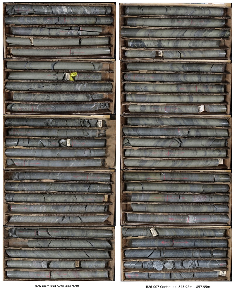
To view an enhanced version of this graphic, please visit:
https://images.newsfilecorp.com/files/7506/294258_glimg14272026.jpg
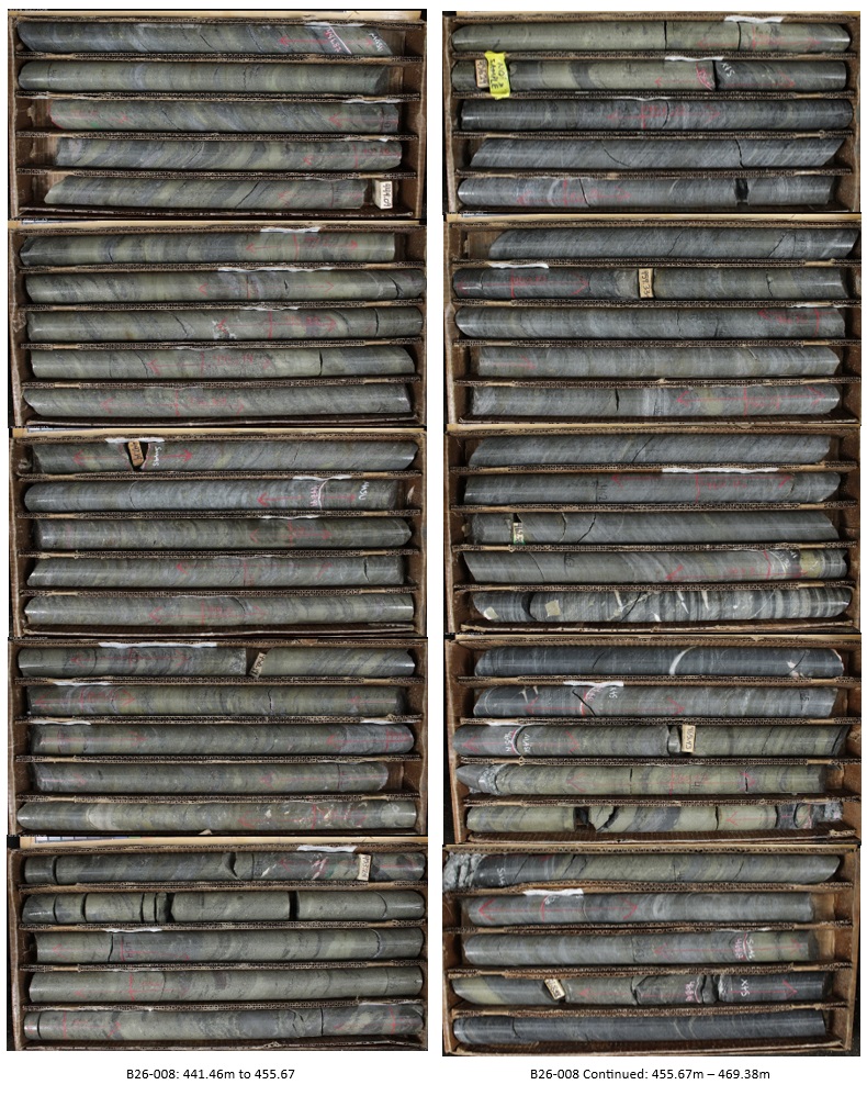
To view an enhanced version of this graphic, please visit:
https://images.newsfilecorp.com/files/7506/294258_glimg24272026.jpg
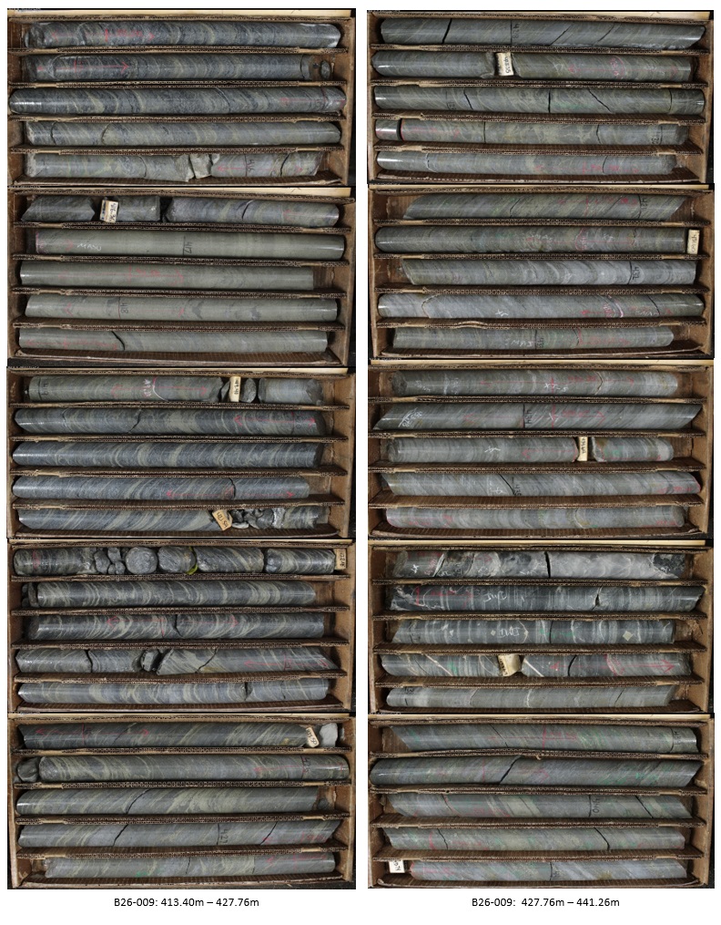
To view an enhanced version of this graphic, please visit:
https://images.newsfilecorp.com/files/7506/294258_glimg34272026.jpg
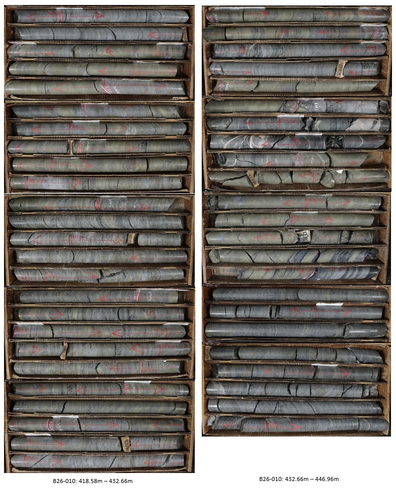
To view an enhanced version of this graphic, please visit:
https://images.newsfilecorp.com/files/7506/294258_glimg44272026.jpg
Sample Preparation and QA/QC
Samples from the 2026 Bend drill program followed strict chain of custody from collection, through processing and delivery to ALS Global's ("ALS") laboratory in Twin Falls, Idaho. The drill core was delivered directly from the drill area to GreenLight's core facility in Medford, WI. The drill core was inspected and sampled by GreenLight's geologists who insert Certified Reference Materials ("CRMS") and Blank material into the sampling stream and make up
Qualified Person Statement
The technical information in this news release has been prepared in accordance with Canadian regulatory requirements as set out in NI 43-101 and reviewed and approved by Thomas Quigley, MSc, CPG-11962, Exploration Director of the Company, a Qualified Person as defined by NI 43-101.
About GreenLight Metals Inc.
GreenLight Metals is a Wisconsin-focused exploration company advancing copper-gold and gold projects across the Penokean Volcanic Belt-one of North America's most prospective VMS districts-and the Kalium Canyon epithermal gold project in Nevada's Walker Lane. In Wisconsin, our portfolio includes the Bend copper-gold deposit, the Reef high-grade gold project, and the Lobo and Lobo East massive sulphide targets. Guided by a team with deep roots in the state, we are building a modern minerals company for Wisconsin, by Wisconsin-committed to responsible exploration, transparent engagement, and creating durable local opportunities as we help supply the critical metals that power the energy transition.
For more information, please contact:
Matt Filgate
President & CEO
(778) 679-3579
matt@greenlightmetals.com
Neither TSX Venture Exchange nor its Regulation Services Provider (as that term is defined in the policies of the TSX Venture Exchange) accepts responsibility for the adequacy or accuracy of this news release.
Forward-Looking Information
This news release contains "forward-looking information" within the meaning of applicable Canadian securities laws, including statements regarding: the timing for receipt and reporting of assay results; the interpretation of visual core observations; the potential significance of the mineralized intervals; the planning, timing, scope and objectives of future work programs; the potential for tellurium to add value to the project; the Company's ability to obtain and maintain required permits and approvals; and the advancement and potential of the Bend Project and the Penokean Volcanic Belt. Forward-looking information is based on reasonable assumptions that management believes are appropriate, including assumptions regarding lab turnaround times, the Company's ability to execute planned programs in a safe and timely manner, availability of equipment and personnel, access to properties, approval timelines, financing availability, and prevailing commodity prices and market conditions.
Forward-looking information is inherently subject to known and unknown risks, uncertainties and other factors that may cause actual results to differ materially from those expressed or implied, including, without limitation: that visual estimates do not correlate with assay results; that assay results are delayed or do not meet expectations; inaccuracies in geological models; changes in project parameters as plans continue to be refined; cost escalations; availability of drill rigs, qualified contractors and supplies; adverse weather or wildfire; operational, health, safety and environmental risks; title, access and permitting risks (including delays or denials of federal, state or local approvals); stakeholder, community or Indigenous engagement risks; regulatory changes; and fluctuations in commodity prices and currency exchange rates. Additional risks are described under the Company's continuous disclosure filings available on SEDAR+.
Although the Company has attempted to identify important factors that could cause actual results to differ materially from those contained in the forward-looking information, there may be other factors that cause results not to be as anticipated, estimated or intended. Readers are cautioned not to place undue reliance on forward-looking information. The forward-looking information in this news release is provided as of the date hereof, and the Company does not undertake any obligation to update such information except as required by applicable law.

To view the source version of this press release, please visit https://www.newsfilecorp.com/release/294258