Western Exploration Provides Update on Drilling Activities at Gravel Creek
- Initial results of the 2023 core drilling program are promising, with high-grade AU-AG vein intercepts reported.
- The CEO's focus on expanding resources within the Wood Gulch/Gravel Creek mineralized system indicates a positive long-term vision for the company.
- The results support further exploration drilling to expand the project resource base.
- None.
Intersects High-Grade AU-AG Veins in the Jarbidge Rhyolite up to 250 Meters North-East of the Current Gravel Creek Resource
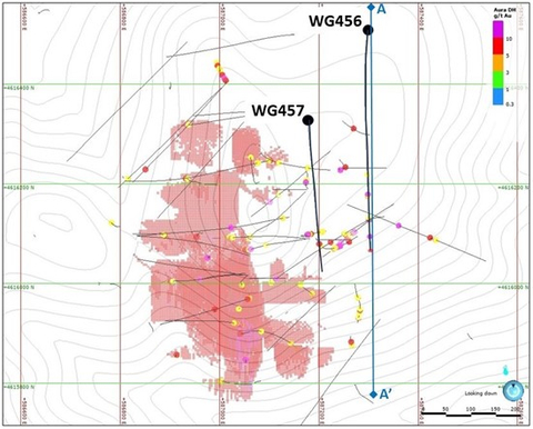
Figure 1. Plan map showing location of 2023 drill holes relative to +3.0 g/t Au Gravel Creek resource blocks. (Graphic: Business Wire)
Highlights from 2023 Drill Program:
- Two oriented core holes totaling 1,470 meters (see Figure 1) were completed to verify the existence of a mineralized corridor trending northeast from the Gravel Creek deposit, as outlined in a news release of the Company dated March 6, 2023, entitled "Western Exploration Announces Additional Exploration Results at Gravel Creek".
- Both holes WG456 and WG457 intersected multiple quartz-pyrite-marcasite bearing veins, stockwork and hydrothermal breccias within the targeted mineralized corridor.
-
Hole WG456, located 250 meters north-east of the Gravel Creek resource area, reported individual assays up to 34.9 g/t Au and 2800.0 g/t Ag, with key intercepts including:
- 4.7 meters of 9.20 g/t AuEq (4.55 g/t Au and 395.4 g/t Ag)
- 2.4 meters of 7.82 g/t AuEq (5.37 g/t Au and 208.1 g/t Ag)
- 2.0 meters of 21.96 g/t AuEq (12.77 g/t Au and 780.9 g/t Ag)
- 2.1 meters of 7.56 g/t AuEq (5.40 g/t Au and 183.1 g/t Ag)
- 3.0 meters of 6.75 g/t AuEq (5.42 g/t Au and 113 g/t Ag)
- Gold-silver grades in WG456 occur at the same elevation as the "productive horizon" in the Gravel Creek deposit and are comparable in grade to those seen in multiple legacy intercepts.
- These results support further exploration drilling to the north-east along a 2.0 kilometers trend of Au-As soil and rock anomalies that parallel a N35E trending density anomaly.
- WG456 was abandoned at a depth of 730.6 meters due to drilling complications, with the final 3.0 meters returning 5.42 g/t Au and 113 g/t Ag.
- Assays for hole WG457 are currently being finalized by ALS Chemex.
Western Exploration CEO, Darcy Marud, commented: "Western Exploration has long believed in the potential to greatly expand resources within the Wood Gulch/Gravel Creek mineralized system, and it is now become more evident that Wood Gulch and Gravel Creek are part of a large Au-Ag bearing hydrothermal system over an area of 10km2. The integration of structural surface alteration and geochemical data generated by the 2023 core drilling program has brought greater understanding of the controls on the high-grade veins in the
Multiple High-Grade Au-Ag Vein Drill Intercepts in the Jarbidge Rhyolite Above and Peripheral to the Gravel Creek Deposit
Previous drilling, as reported in the Technical Report (as defined herein), intersected multiple high-grade Au-Ag bearing vein intercepts of up to 40.05 g/t Au and 1951.0 g/t Ag in the Miocene Jarbidge volcanics overlying and lateral to the Gravel Creek deposit. None of these
Drill results for hole WG456, intersected 9 veins, stockwork or hydrothermal breccias, which identified AuEq grades of over 3.0 g/t. Key intercepts are shown in Figure 2 and all +3.0 g/t AuEq results are summarized in Table 1, with coordinates shown in Table 2.
A preliminary review of oriented core data shows an array of intersecting veins, stockwork and hydrothermal breccias following north-west to north-east trends that mimic the known structural controls on mineralization. Flow banded zones within the rhyolite show strong preferential steeply dipping north-east trends, which control the emplacement of certain veins and hydrothermal breccia zones.
Table 1. Summary of +3.0 g/t AuEq intercepts in core hole WG456 testing the
START |
END |
Interval(1) |
AuEq(2) |
Au |
Ag |
|
HOLE(3) |
(m) |
(m) |
(m) |
(ppm) |
(ppm) |
(ppm) |
WG456 |
469.7 |
470.1 |
0.3 |
5.21 |
1.90 |
282 |
WG456 |
479.4 |
479.7 |
0.3 |
4.91 |
4.70 |
17.8 |
WG456 |
544.5 |
549.3 |
4.7 |
9.20 |
4.55 |
395.4 |
with |
546.4 |
548.2 |
1.8 |
20.05 |
9.77 |
874 |
or |
546.4 |
546.7 |
0.3 |
67.84 |
34.9 |
2800 |
WG456 |
553.4 |
558.1 |
4.7 |
4.17 |
2.24 |
163.3 |
with |
553.4 |
555.4 |
1.9 |
6.41 |
3.82 |
219.9 |
or |
553.4 |
553.9 |
0.5 |
10.66 |
4.34 |
537 |
WG456 |
569.3 |
570.2 |
0.9 |
4.19 |
2.87 |
112 |
WG456 |
625.6 |
629.1 |
3.5 |
6.64 |
4.59 |
174.6 |
with |
625.6 |
628 |
2.4 |
7.82 |
5.37 |
208.1 |
WG456 |
631.1 |
633.1 |
2.0 |
21.96 |
12.77 |
780.9 |
with |
631.1 |
632.2 |
1.0 |
31.95 |
19.60 |
1050 |
WG456 |
683.9 |
686 |
2.1 |
7.56 |
5.40 |
183.1 |
with |
685.6 |
686 |
0.4 |
26.03 |
18.85 |
610 |
WG456 |
727.60 |
730.60 |
3.00 |
6.75 |
5.42 |
113.0 |
Notes:
(1) |
Intervals are calculated with minimum grades of 3.0 g/t AuEq. True widths are estimated at 30 |
|
(2) |
Assays are uncut and as received. AuEq calculated at a ratio of 85:1 of Ag:Au. |
|
(3) |
WG456 terminated in mineralization due to drilling issues. |
Table 2. Collar coordinates for Gravel Creek holes referenced in this press release.
Hole ID |
East |
North |
Elev |
Azimuth |
Dip |
Depth (m) |
| WG456 | 587,298 |
4,616,507 |
2,185 |
186.3 |
48.1 |
727.3 |
| WG457 | 587,178 |
4,616,351 |
2,198 |
180.0 |
62.1 |
743.0 |
Results Support Further Exploration Drilling Along North-East Trend.
Results from drill hole WG456, in combination with 2020 core hole WG450, identified multiple drill intercepts with significant Au-Ag grades in a zone 200 meters wide near the north-east limit of current drilling area (see Figure 3). This provides additional support for exploration potential associated with the strong multi-element soil anomaly and coincident density anomaly extending from Wood Gulch through Gravel Creek and continuing 2.0 kilometers to the north-east of the Gravel Creek deposit (see Figure 4).
ABOUT THE AURA PROJECT
In addition to an established mineral resource estimate outlined in the Technical Report, the Aura Project has well established infrastructure, including year-round accessibility by highway and county-maintained road, with nearby access to water and electricity (see Figure 5). Western Exploration has exploration, development, and mining rights on 930 hectares of privately owned fee lands through a mineral lease agreement with a local landowner and may purchase those fee lands at any time for the development of Doby George.
The 6,000-hectare Aura Project is unique in the junior mining space, as resources have been identified in three different deposits (Doby George, Gravel Creek and Wood Gulch), as supported by the Technical Report (see Table 3 below).
Table 3. Updated mineral resource estimate for the Aura Project as contained in the Technical Report
MINERAL RESOURCE ESTIMATE(1) |
||||||||||||||
|
Indicated |
Inferred |
||||||||||||
Tonnes |
Au (g/t) |
Au
|
Ag (g/t) |
Ag
|
AuEq (g/t) |
AuEq (oz.) |
Tonnes |
Au (g/t) |
Au
|
Ag (g/t) |
Ag
|
AuEq (g/t) |
AuEq (oz.) |
|
Doby George(2) |
12,922,000 |
0.98 |
407,000 |
- |
- |
0.98 |
407,000 |
4,999,000 |
0.73 |
118,000 |
- |
- |
0.73 |
118,000 |
Wood Gulch(3) |
- |
- |
- |
- |
- |
- |
- |
4,359,000 |
0.66 |
93,000 |
5.80 |
808,000 |
0.74 |
104,543 |
Gravel Creek(4) |
1,315,000 |
4.73 |
200,000 |
75.0 |
3,169,000 |
5.81 |
245,271 |
2,744,000 |
4.16 |
367,000 |
60.20 |
5,307,000 |
5.02 |
442,814 |
TOTAL |
14,237,000 |
1.33 |
607,000 |
75.0 |
3,169,000 |
1.43 |
652,271 |
12,102,000 |
1.48 |
578,000 |
15.74 |
6,115,000 |
1.71 |
665,357 |
Notes:
(1) |
Au equivalent oz assumes |
|
(2) |
Pit constrained 0.2 g/t AuEq cutoff for oxide, 0.4 g/t Au cutoff for mixed and 1.4 g/t Au cutoff for unoxidized. |
|
(3) |
Pit constrained 0.2 g/t AuEq cutoff. |
|
(4) |
3.0 g/t Au cutoff. |
The mineral resource estimate for the Aura project is disclosed in the Company's technical report, prepared in accordance with National Instrument 43-101 – Standards of Disclosure for Mineral Projects ("NI 43-101"), entitled "2021 Updated Resource Estimates and Technical Report for the Aura Gold-Silver Project,
About Western Exploration
Born from a 25-year history of advancing exploration projects in
Qualified Person Approval
The scientific and technical content in this news release has been reviewed and approved by Mark Hawksworth, General Manager of the Aura Project, and a "qualified person" within the meaning of NI 43-101.
Quality Assurance – Quality Control
Drill program design, Quality Assurance/Quality Control ("QA/QC") and the interpretation of results is performed by qualified persons employing a QA/QC program consistent with NI 43-101 and industry best practices.
Drill core samples were delivered by Major Drilling to Western Exploration's secure warehouse/logging facility in
Drill core samples were transported by Neilsen Exploration to ALS Chemex located in
Please see below under the heading "Cautionary Note Regarding Forward-Looking Information" for further details regarding the risks facing Western Exploration.
For additional information on the Aura Project, please see the Technical Report, which has been prepared in accordance with the requirements of NI 43-101, a copy of which is available on SEDAR+ (www.sedarplus.ca) under Western Exploration's issuer profile and on Western Exploration's corporate website (www.westernexploration.com).
Cautionary Statements Regarding Estimates of Mineral Resources
This news release uses the terms measured, indicated and inferred mineral resources as a relative measure of the level of confidence in the resource estimate. Readers are cautioned that mineral resources are not mineral reserves and that the economic viability of resources that are not mineral reserves has not been demonstrated. The mineral resource estimate disclosed in this news release may be materially affected by geology, environmental, permitting, legal, title, socio-political, marketing or other relevant issues. The mineral resource estimate is classified in accordance with the Canadian Institute of Mining, Metallurgy and Petroleum's "CIM Definition Standards on Mineral Resources and Mineral Reserves" (CIM) incorporated by reference into NI 43-101. Under NI 43-101, estimates of inferred mineral resources may not form the basis of feasibility or pre-feasibility studies or economic studies except for preliminary economic assessments. Readers are cautioned not to assume that further work on the stated resources will lead to mineral reserves that can be mined economically.
Inferred mineral resources have a great amount of uncertainty as to their existence and as to whether they can be mined legally or economically. On October 31, 2018, the SEC adopted new mining disclosure rules ("S-K 1300") that are more closely aligned with current industry and global regulatory practices and standards, including NI 43-101, although there are some differences in the two standards. Accordingly, information concerning mineral deposits contain in this release may not be comparable with information made public by
Cautionary Note Regarding Forward-Looking Information
This news release may contain "forward-looking information" and "forward-looking statements" within the meaning of the applicable Canadian and
For additional information with respect to these and other factors and assumptions underlying the forward‐looking statements and forward-looking information made in this news release concerning Western Exploration, see the management information circular dated November 12, 2021, available electronically under Western Exploration's issuer profile on SEDAR (www.sedar.com). The forward-looking statements set forth herein concerning Western Exploration reflect management's expectations as at the date of this news release and are subject to change after such date. Western Exploration disclaims any intention or obligation to update or revise any forward-looking statements, whether as a result of new information, future events or otherwise, other than as required by law.
Neither the TSX Venture Exchange nor its Regulation Services Provider (as that term is defined in the policies of the TSX Venture Exchange) accepts responsibility for the adequacy or accuracy of this news release. No stock exchange, securities commission or other regulatory authority has approved or disapproved the information contained herein.
View source version on businesswire.com: https://www.businesswire.com/news/home/20231121272890/en/
Darcy Marud
Chief Executive Officer
Telephone: (775) 329-8119
Email: dmarud@westernexploration.com
Nichole Cowles
Investor Relations
Telephone: 775-240-4172
Email: nicholecowles@westernexploration.com
Source: Western Exploration Inc.
FAQ
What are the key highlights of Western Exploration Inc.'s (WEX) 2023 core drilling program?
What is the CEO's vision for the company's Wood Gulch/Gravel Creek mineralized system?