Blue Lagoon Completes Airborne Geophysical Survey - Reports Latest Drill Results
VANCOUVER, BC / ACCESSWIRE / October 6, 2020 / Blue Lagoon Resources Inc. (the "Company") (CSE:BLLG)(FSE:7BL)(OTCQB:BLAGF) is pleased to announce completion of the field phase of airborne geophysical surveys over its Dome Mountain Gold Project, located a short 50-minute drive from the town of Smithers B.C.
These surveys, which were flown by Precision GeoSurveys Inc. of Canada, provide the Company with detailed low altitude (helicopter-borne) Magnetic, Electromagnetic ("EM") and Radiometric data, and were completed in two different phases with 1173.3 km of mag/radiometrics and 1475.5 km of EM/mag, both at 100m line separation.
"This is an important milestone for Dome Mountain as it's the first time that this type of leading-edge, deep-penetrating airborne survey has been flown on the property,
The new Mag images reveal a prominent northwest trending structural zone defined by two parallel, linear magnetic anomalies interpreted to reflect mafic dikes intruded along a pair of faults. Several minor linear magnetic anomalies occur between and adjacent to these main structures and suggest a complex fracture system which may provide sites for vein-style gold mineralization. In addition, at least five positive, circular magnetic anomalies are interpreted to reflect small (approximately 400m to 800m diameter) intrusions into the volcanic and sedimentary Hazelton Group host rocks. At least one of these is surrounded by a concentric magnetic depression suggestive of possible alteration systems (see white dotted ellipse on Figure 1, number 3). These five circular magnetic anomalies present potential Porphyry Copper/Gold/Moly style exploration targets for the Company to pursue.
Ground truthing and field prospecting has not yet been completed on most of the property and will be part of the ongoing exploration program in 2021.
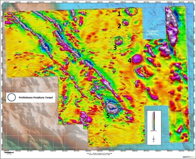
Figure 1
Based on the results of the Mag survey, conclusions can be made on specific targets within the property boundaries. For example, the Freegold showing, located about 1.4km NE from the Boulder Vein system, shows a clear and concentric Mag signature. Gold is hosted in quartz veins and assessment reports point to the anomalous nature of the samples collected. Historic maps show the Freegold veins as narrow NW trending veins hosted by both Monzonite on the eastern end and Hazleton Volcanics on their western end. Investigation and sampling in 2020 showed that these veins are indeed narrow however, where they outcrop on surface, they are found to trend nearly due west. In Figure 1 (5) the recent airborne Mag shows Freegold highlighted by a strong circular Mag feature with an inner core of very low Mag value (Figure 2). Within this low Mag zone, lies the Freegold Veins. This Low Mag zone is nearly one kilometer in length and up to 300 meters in width and offers a very good target for further drill testing.
The Freegold Showing is easily accessible by established gravel roads on the Dome Mountain Property.
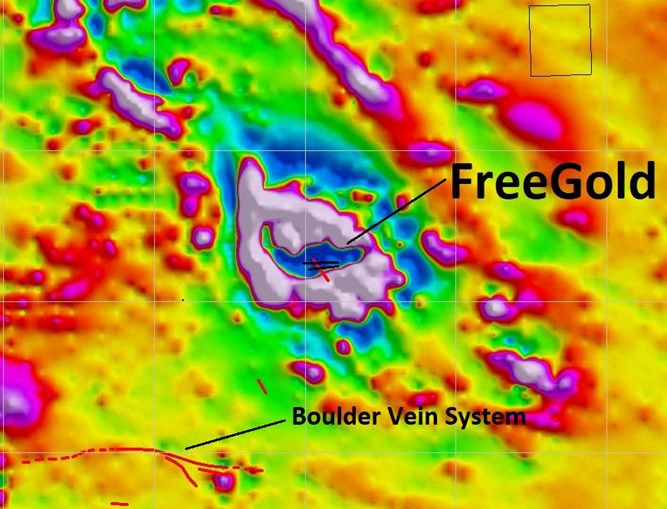
Figure 2
(Scale: Each square in the figure represents an area of 1km X 1 km)
In addition, the new Mag data shows a clear structural association with mineralization encountered in drill hole DM-20-114 which was drilled as part of the Phase One drill program at Dome Mountain this summer.
Reported intercepts included 107 g/t Au and 278.5 g/t Ag over 1.42m and, 173.4 g/t Au and 1017 g/t Ag over 0.17m (see the Company's news release dated September 28, 2020). The importance of this drill hole drilled within the near mine inferred resource resides in the fact that it hit mineralization on the other side of a NE trending fault and may continue on strike to the east/south east along a structure clearly defined by the recent airborne Mag Survey (Figure 3). This magnetic structure trends for at least 1.5 kilometres.
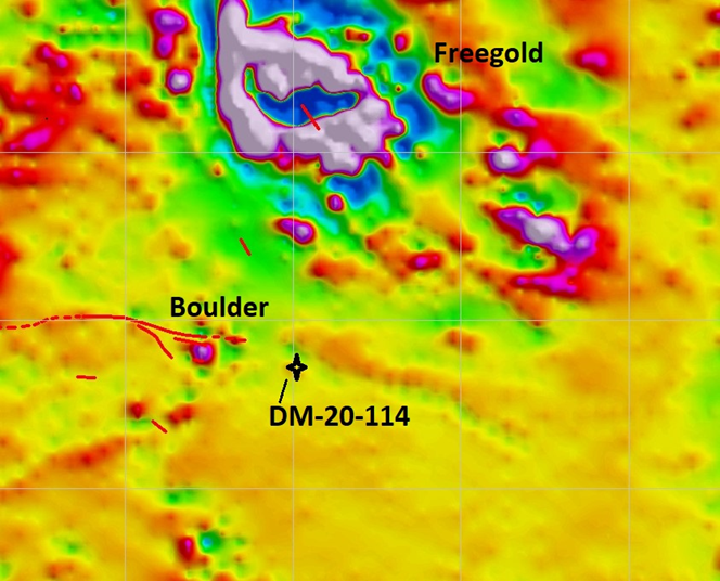
Figure 3
(Scale: Each square in the figure represents an area of 1km X 1 km)
Further testing by drilling along strike will occur when drilling resumes later this year / early next year.
Work in the future, including drilling, soil sampling, prospecting, and mapping will focus on the presence of strong geophysical structures and intrusive bodies identified by the completed Airborne Mag program over known mineralization. Once analysis of the EM portion of the Airborne survey is completed, the Company will prioritize its exploration drill targets for its next drill program.
Bill Cronk, Chief Geologist for Blue Lagoon Resources stated "The contrast shown by the recent Mag survey clearly identifies promising targets for follow-up. Several of these targets have already been sampled by soils as well as prospecting and the Freegold feature (number 5 in figure 1 and, Figure 2) is clearly a drill ready target. In addition, we are very exited to see that our recent drilled intercept in hole DM-20-114 shows a clear structural association identified by the MAG and further drilling will be a priority once drilling starts again in late December or early January (Figure 3)".
DRILLING UPDATE
The latest assay results from more holes completed during the Phase One drill program have been received. Core drilling of the previously announced 3,700-meter work program which was designed to focus on upgrading a significant portion of the inferred mineral resource to the indicated category, is now complete and the first assay results have been reported for holes DM-20-114 and DM-20-115. Figure 4 shows all the drill holes completed during the Phase One Program, highlighting holes DM-20-114 and DM-20-115 (in blue) announced last week, and shows holes in green with the new results.
Further, Figure 4 shows the location of the drill holes relative to the near mine infrastructure including locations of the phase one drill collars and historic drilling relative to the 1290 portal, the office and dry, the mine shop and the water treatment plant.
Recent assay results include DM-20-116, DM-20-118, DM-20-119, DM-20-120, DM-20-121,
DM-20-122, DM-20-123 and DM-20-124 with select results given in Table 1 below.
Figure 5 shows the down-hole sections.
TABLE 1
Hole ID | Sample # | From | To | Interval | Ag (g/t) | Au (g/t) |
DM-20-116 | 2626178 | 13.60 | 14.00 | 0.40 | 13 | 7.9 |
DM-20-116 | 2626181 | 15.90 | 16.25 | 0.35 | 89 | 6.2 |
DM-20-118 | 2626197 | 172.60 | 173.74 | 1.14 | 4 | 4.0 |
DM-20-118 | 2626199 | 182.60 | 183.20 | 0.60 | 39 | 6.4 |
DM-20-118 | 2626202 | 188.48 | 189.40 | 0.92 | 59 | 11.3 |
DM-20-119 | 2626209 | 142.40 | 142.97 | 0.57 | 16 | 8.1 |
DM-20-120 | 2626220 | 159.88 | 160.28 | 0.40 | 85 | 16 |
DM-20-120 | 2626223 | 166.12 | 167.70 | 1.58 | 4 | 1.0 |
DM-20-121 | 2626244 | 160.04 | 160.36 | 0.32 | 6 | 1.9 |
DM-20-122 | 2626254 | 150.87 | 151.20 | 0.33 | 4 | 2.9 |
DM-20-123 | 2626258 | 119.93 | 120.43 | 0.50 | 34 | 12.7 |
DM-20-123 | 2626264 | 123.48 | 124.35 | 0.87 | 16 | 3.9 |
DM-20-123 | 2626265 | 124.35 | 125.80 | 1.45 | 21 | 7.1 |
DM-20-124 | 2626273 | 116.26 | 116.41 | 0.15 | 14 | 3.6 |
DM-20-124 | 2626276 | 117.87 | 118.20 | 0.33 | 61 | 12.1 |
DM-20-124 | 2626277 | 118.20 | 118.68 | 0.48 | 87 | 18.8 |
DM-20-124 | 2626279 | 118.68 | 119.00 | 0.32 | 17 | 2.7 |
DM-20-124 | 2626281 | 119.00 | 119.45 | 0.45 | 15 | 2.9 |
Select intercepts for recent results of Phase One drilling
Significant Drill Results Include:
- Hole DM-20-118 11.3 g/t Au and 59 g\t Ag over 0.92 meters
- Hole DM-20-119 8.1 g/t Au and 16 g\t Ag over 0.57 meters
- Hole DM-20-120 4.03 g/t Au and 20.36 g\t Ag over 1.98 meters
- Hole DM-20-123 12.7 g/t Au and 34 g\t Ag over 0.50 meters
- Hole DM-20-124 9.61 g/t Au and 46.88 g\t Ag over 1.58 meters
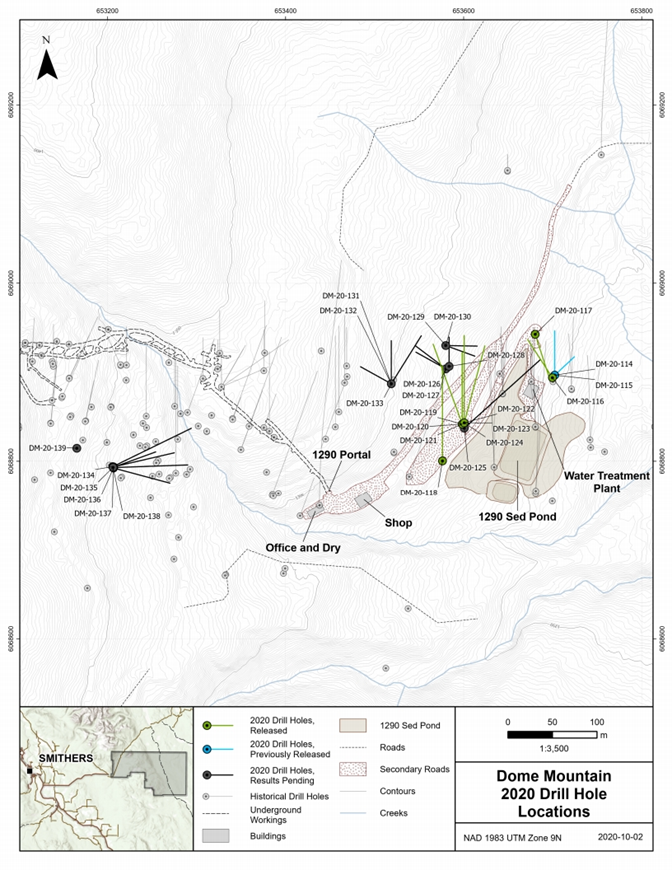
Figure 4
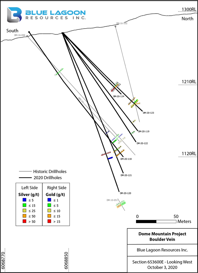
Figure 5
The scientific and technical data contained in this news release was approved by William Cronk, P.Geo., a qualified person as defined in NI 43-101 and a consultant to the Company.
For further information, please contact:
Rana Vig
President and Chief Executive Officer Telephone: 604-218-4766
Email: rana@ranavig.com
The CSE has not reviewed and does not accept responsibility for the adequacy or accuracy of this release.
This release includes certain statements that may be deemed "forward-looking statements". All statements in this release, other than statements of historical facts, that address events or developments that Blue Lagoon Resources Inc. (the "Company") expects to occur, are forward-looking statements. Forward-looking statements are statements that are not historical facts and are generally, but not always, identified by the words "expects", "plans", "anticipates", "believes", "intends", "estimates", "projects", "potential" and similar expressions, or that events or conditions "will", "would", "may", "could" or "should" occur. Although the Company believes the expectations expressed in such forward-looking statements are based on reasonable assumptions, such statements are not guarantees of future performance and actual results may differ materially from those in the forward-looking statements. Factors that could cause the actual results to differ materially from those in forward-looking statements include results of exploration activities that may not show quality and quantity necessary for upgrading mineralization classification or for further exploration and exploitation of minerals deposits, market prices, and continued availability of capital and financing, permitting and other approvals, and general economic, market or business conditions. Investors are cautioned that any such statements are not guarantees of future performance and actual results or developments may differ materially from those projected in the forward-looking statements. Forward-looking statements are based on the beliefs, estimates and opinions of the Company's management on the date the statements are made. Except as required by applicable securities laws, the Company undertakes no obligation to update these forward-looking statements in the event that management's beliefs, estimates or opinions, or other factors, should change.
SOURCE: Blue Lagoon Resources Inc.
View source version on accesswire.com:
https://www.accesswire.com/609280/Blue-Lagoon-Completes-Airborne-Geophysical-Survey--Reports-Latest-Drill-Results


