Solis Announces Additional High-Grade Copper Confirmed at Cinto, Peru
Solis Minerals (ASX: SLM) has announced additional high-grade copper mineralization at its Cinto Project in Peru. Recent channel sampling revealed significant results, including 26.5m @ 0.28% Cu (Channel 11), with a high-grade section of 5.4m @1.0% Cu. Previous sampling had shown results of 23.4m @ 0.88% Cu and 16.8m @ 0.52% Cu.
The copper mineralization extends across a potential area of 3km long and 0.75km wide. The project is located 15km southeast of the Toquepala mine, one of Peru's largest copper operations. Four distinct mineralization types have been identified, predominantly in breccias. The company has initiated permitting for drilling scheduled to begin in the second half of 2025.
The project's geological setting along the Incapuquio Fault System is considered favorable for large-scale porphyry copper deposits. Geophysical data from drone magnetometry supports scale potential and highlights new target areas.
Solis Minerals (ASX: SLM) ha annunciato ulteriori mineralizzazioni di rame ad alto tenore nel suo Progetto Cinto in Perù. Campionamenti recenti a canale hanno evidenziato risultati significativi, tra cui 26,5 m @ 0,28% Cu (Canale 11), con una sezione ad alto tenore di 5,4 m @ 1,0% Cu. Campionamenti precedenti avevano mostrato risultati di 23,4 m @ 0,88% Cu e 16,8 m @ 0,52% Cu.
La mineralizzazione del rame si estende su un’area potenziale di 3 km di lunghezza per 0,75 km di larghezza. Il progetto si trova a 15 km a sud-est della miniera di Toquepala, una delle più grandi operazioni di rame in Perù. Sono stati identificati quattro tipi distinti di mineralizzazione, prevalentemente in brecce. La società ha avviato le procedure per i permessi di perforazione, prevista per la seconda metà del 2025.
L’ambientazione geologica del progetto lungo il Sistema di faglie Incapuquio è ritenuta favorevole per depositi porfirici di rame su larga scala. I dati geofisici ottenuti tramite magnetometria con droni supportano il potenziale di ampia estensione e evidenziano nuove aree target.
Solis Minerals (ASX: SLM) ha anunciado una mineralización adicional de cobre de alta ley en su Proyecto Cinto en Perú. Muestreos recientes en canal revelaron resultados significativos, incluyendo 26,5 m @ 0,28% Cu (Canal 11), con un tramo de alta ley de 5,4 m @ 1,0% Cu. Muestreos previos mostraron resultados de 23,4 m @ 0,88% Cu y 16,8 m @ 0,52% Cu.
La mineralización de cobre se extiende a lo largo de un área potencial de 3 km de largo por 0,75 km de ancho. El proyecto está ubicado a 15 km al sureste de la mina Toquepala, una de las mayores operaciones de cobre en Perú. Se han identificado cuatro tipos distintos de mineralización, principalmente en brechas. La empresa ha iniciado los trámites para los permisos de perforación, programada para la segunda mitad de 2025.
El entorno geológico del proyecto a lo largo del Sistema de Fallas Incapuquio se considera favorable para depósitos porfíricos de cobre a gran escala. Los datos geofísicos obtenidos mediante magnetometría con drones respaldan el potencial de escala y destacan nuevas áreas objetivo.
Solis Minerals (ASX: SLM)는 페루에 위치한 Cinto 프로젝트에서 추가적인 고품위 구리 광화 작용을 발표했습니다. 최근 채널 샘플링에서 26.5m @ 0.28% Cu (채널 11)를 포함한 유의미한 결과가 나왔으며, 그 중 5.4m 구간은 1.0% Cu의 고품위 구리 구간이 확인되었습니다. 이전 샘플링에서는 23.4m @ 0.88% Cu와 16.8m @ 0.52% Cu의 결과가 보고되었습니다.
구리 광화는 길이 3km, 폭 0.75km의 잠재적 구역에 걸쳐 분포합니다. 이 프로젝트는 페루 최대 구리 광산 중 하나인 토케팔라 광산에서 남동쪽으로 15km 떨어진 곳에 위치해 있습니다. 주로 브레치아 내에서 네 가지 뚜렷한 광화 유형이 확인되었습니다. 회사는 2025년 하반기 시작 예정인 시추를 위한 허가 절차를 진행 중입니다.
프로젝트의 지질학적 환경은 인카푸키오 단층 시스템을 따라 대규모 포피리 구리 광상에 적합한 것으로 평가됩니다. 드론 자기탐사로 수집된 지구물리학적 데이터는 규모 잠재력을 뒷받침하며 새로운 목표 구역을 강조합니다.
Solis Minerals (ASX: SLM) a annoncé une minéralisation supplémentaire de cuivre à haute teneur sur son projet Cinto au Pérou. Des échantillonnages récents en canal ont révélé des résultats significatifs, notamment 26,5 m @ 0,28% Cu (Canal 11), avec une section à haute teneur de 5,4 m @ 1,0% Cu. Des échantillonnages antérieurs avaient montré des résultats de 23,4 m @ 0,88% Cu et 16,8 m @ 0,52% Cu.
La minéralisation du cuivre s’étend sur une zone potentielle de 3 km de long et 0,75 km de large. Le projet est situé à 15 km au sud-est de la mine Toquepala, l’une des plus grandes opérations de cuivre du Pérou. Quatre types distincts de minéralisation ont été identifiés, principalement dans des brèches. La société a lancé les démarches pour obtenir les permis de forage, prévu pour le second semestre 2025.
Le contexte géologique du projet le long du système de failles Incapuquio est considéré comme favorable aux dépôts porphyriques de cuivre à grande échelle. Les données géophysiques issues de la magnétométrie par drone confirment le potentiel d’envergure et mettent en lumière de nouvelles zones cibles.
Solis Minerals (ASX: SLM) hat zusätzliche hochgradige Kupfermineralisierung bei seinem Cinto-Projekt in Peru bekanntgegeben. Jüngste Kanalproben ergaben bedeutende Ergebnisse, darunter 26,5 m @ 0,28% Cu (Kanal 11), mit einem hochgradigen Abschnitt von 5,4 m @ 1,0% Cu. Frühere Proben zeigten Ergebnisse von 23,4 m @ 0,88% Cu und 16,8 m @ 0,52% Cu.
Die Kupfermineralisierung erstreckt sich über ein potenzielles Gebiet von 3 km Länge und 0,75 km Breite. Das Projekt liegt 15 km südöstlich der Toquepala-Mine, einer der größten Kupferbergwerke Perus. Es wurden vier verschiedene Mineralisierungstypen identifiziert, überwiegend in Brekzien. Das Unternehmen hat die Genehmigungsverfahren für Bohrungen eingeleitet, die in der zweiten Hälfte 2025 beginnen sollen.
Die geologische Lage des Projekts entlang des Incapuquio-Verwerfungssystems gilt als günstig für großflächige Porphyr-Kupferlagerstätten. Geophysikalische Daten aus Drohnenmagnetometrie stützen das Potenzial und heben neue Zielgebiete hervor.
- High-grade copper mineralization confirmed with significant channel sample results
- Large potential mineralization area of 3km x 0.75km identified
- Strategic location near major Toquepala copper mine (2.1Bt @ 0.47% Cu)
- Geophysical data supports scale potential with new target areas
- Drilling not yet commenced - permits pending
- systematic exploration completed to date
- No previous drill programs on record
HIGHLIGHTS
More copper porphyry mineralisation identified at Cinto (
100% Solis Minerals) from channel sample assays (highlights):26.5m @
0.28% Cu (Channel 11), including 5.4m @1.0% Cu
Previous Cinto channel sample assays returned highlights1:
23.4m @
0.88% Cu (Channel 1)16.8m @
0.52% Cu (Channel 6)Results indicate porphyry copper mineralisation of various styles across a potential area 3km long and 0.75km wide.
Induced-Polarisation (IP) survey planning underway to support drill target definition.
Permitting initiated for drilling at Cinto in second half of 2025.
Solis Minerals considers copper mineralisation at Cinto consistent with nearby Toquepala (one of Peru's largest copper mines with 2.1Bt @
0.47% Cu - 200ktpa Cu production)2.
West Leederville, Western Australia--(Newsfile Corp. - April 22, 2025) - Latin American focused copper-gold explorer Solis Minerals Limited (ASX: SLM) ("Solis Minerals" or the "Company") is pleased to announce an update on copper mineralisation identified in channel samples at the Cinto Project in Peru.
Chief Executive Officer, Mitch Thomas, commented:
"These results confirm the significant potential at the Cinto Project, where we've substantially expanded Solis' porphyry copper mineralisation footprint. Notably, we're seeing mineralisation styles similar to those at the major Toquepala mine, just 15km away. Geophysical data from drone magnetometry supports scale potential and highlights new target areas. As a stand-alone project, Cinto is a compelling copper porphyry target.
Our on-ground team recently hosted site visits for our technical director Mike Parker and myself across our project portfolio. Visible mineralisation at surface at Ilo Este and Cinto was a highlight. The clear, visible prospectivity in our projects very much aligns with our objective of identifying copper-gold resources that have potential to host large-scale mining in one of the world's leading copper producing regions.
With drilling set to begin at Chancho al Palo3 and Ilo Este this quarter, and Cinto advancing toward drilling in the second half of 2025, Solis Minerals' portfolio of
Summary
Exploration results at Cinto from channel sampling (Table 1) show a continuation of the mineralised breccia zones previously announced on 11 February 2025. A new channel, Channel 11, situated between previously reported Channels 7 and 8, reported 26.5m @
The copper mineralisation encountered at Cinto to date is predominantly in breccias, the major mineralisation host at Toquepala, 15km northwest of Cinto. Four mineralisation types have been identified in distinct zones. Cinto is situated on the major Incapuquio Fault System which favoured the emplacement of intrusions related to large-scale porphyry copper deposits of Toquepala, Quellaveco, and Cuajone (Figure 1). Toquepala is one of Peru's oldest and largest copper producers (200ktpa copper production).

Figure 1: Cinto tenements and neigbouring Toquepala operation and peer concession holders.
To view an enhanced version of this graphic, please visit:
https://images.newsfilecorp.com/files/1134/249429_fd7e51d1043b5b63_001full.jpg
Cinto Project
The Cinto Project consists of six granted tenements totalling 2,700Ha and five applications totalling 2,800Ha in the highly prospective Cenozoic Porphyry Belt of southern Peru, located some 15km to the southeast of the world class Toquepala Copper Mine (Figure 1). Cinto is geologically distinct from the rest of Solis' tenements which are situated in the older Jurassic-Cretaceous Coastal Belt of Peru (Figure 2).

Figure 2: Solis' tenements in the Coastal and Cenozoic (Paleocene-Eocene) Belts with existing deposits and regional geology shown. Note new permit applications made north of Cinto in January 2025.
To view an enhanced version of this graphic, please visit:
https://images.newsfilecorp.com/files/1134/249429_fd7e51d1043b5b63_002full.jpg
In addition to the rock geochemistry results reported on February 11, 2025, further results of rock and channel geochemistry sampling programs carried out at Cinto in the first quarter of 2025 continue to yield highly encouraging results that confirm porphyry mineralisation over a broad area. Rock samples were collected from outcrops of interest or on a sampling grid, whilst channel samples were continuous samples taken across zones of outcropping mineralisation, usually related to old workings or eroded gullies.
Channels 11 and 12 were sampled in an eroded gully zone between previously reported Channels 7, 8, and 9. Channel 11, situated between previously reported Channels 7 and 8, reported 26.5m @
Field observations at the site of Channels 7-9, and 11-12 (this release), show that the intrusive hydrothermal breccia is massive in nature with undefined limits due to poor exposure. The channel sample results therefore do not represent a true width of mineralisation.
A strong correlation is identified between copper mineralisation defined in the geochemical program and previously reported magnetic low geophysical anomalies4 (Figure 4). In the northeast of the licence, all channel samples and the majority of copper-anomalous rock samples fall within a magnetic low of dimensions 3km x 0.75km with the low core having a surface area of 1.75km2 creating scope for scale. This magnetic low anomaly is interpreted as being caused by magnetite destruction, a common occurrence in porphyry deposits where late-stage mineralising fluids react with magnetic minerals in a host rock, altering them to non-magnetic mineral species.

Figure 3: Solis Minerals' exploration team and CEO Mitch Thomas with Technical Director Mike Parker during a site visit in April 2025, which included a visit to Cinto, Ilo Este and Chancho al Palo.
To view an enhanced version of this graphic, please visit:
https://images.newsfilecorp.com/files/1134/249429_fd7e51d1043b5b63_003full.jpg

Figure 4: Intrusive hydrothermal breccia with angular, poorly sorted volcanic clasts and a quartz breccia matrix with Cu oxides. Channel 11. Sample 18621 - 335710E, 8079715N. Assays 0,011g/t Au, 1.4g/t Ag,
To view an enhanced version of this graphic, please visit:
https://images.newsfilecorp.com/files/1134/249429_fd7e51d1043b5b63_004full.jpg
Previous Exploration
Prior to Solis Minerals acquiring the Cinto tenements, limited systematic exploration had been completed and there are no records of previous drill programs. Solis Minerals commenced exploration with a WorldView-3 remote sensing survey, followed up by geological mapping. In 2023 and 2024, reconnaissance rock sampling led to the identification of an area of in-situ copper oxide mineralisation in old workings in the northeast of the property. Solis Minerals completed a drone magnetometry survey that identified areas of low magnetic response coincident and extending beyond the reconnaissance mineralisation4. Rock and channel sampling was expanded in late 2024 with some 530 samples taken in total. Previous exploration results are summarised in Figures 5 and 6.

Figure 5: Previous exploration at Cinto: Total Field magnetic data (high magnetic response in red, low response in blue) overlaid by WorldView-3 alteration suites and geology/structure. "Cu" marks zone of high-grade copper oxide samples from old workings, the original reconnaissance site sampled 1H 2024.
To view an enhanced version of this graphic, please visit:
https://images.newsfilecorp.com/files/1134/249429_fd7e51d1043b5b63_005full.jpg
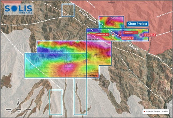
Figure 6: Cinto locality map of channel sampling areas underlain by total field drone magnetometry. Note that the channel sampling is located in zones of low magnetic response (blue-green colours) indicating hydrothermal alteration. The magnetometry is a valuable guide for exploration at Cinto.
To view an enhanced version of this graphic, please visit:
https://images.newsfilecorp.com/files/1134/249429_fd7e51d1043b5b63_007full.jpg
Cinto Structural Setting
Cinto sits astride or just south of the regional transcurrent Incapuquio Fault System (Figures 1 & 6). The fault's corridor of influence includes en echelon faults, and subparallel fault structures. In the Cinto area, the fault corridor has an approximate width of 2.5km across its predominant NW-SE strike direction. This fault system is believed to have influenced the emplacement of Late Cretaceous to Early Palaeogene (Cenozoic) granodioritic, dioritic, and monzonitic intrusions as well as related volcanic rocks of the Toquepala Group5. The large-scale copper porphyry deposits of Cuajone, Quellaveco, and Toquepala were formed during this intrusive phase (Figure 2) and are associated with, or emplaced within, volcanics of the Toquepala Group.
Cinto Geochemical Sampling 2025
During Q1 2025, 125 rock samples were collected (Tables 1-4). Of these, 102 were outcrop rock samples and 23 were channel samples from 2 separate channels. Channel sampling was carried out in an area of good to continuous outcrop, principally facilitated by gully erosion. The Q1 2025 program complements the 2023/20242 geochemistry and brings the total rock sampling inventory at Cinto to 655 samples.
The 23 channel sample results from the Q1 2025 program are summarised in Table 1 with details in Table 3, Appendix 1.
Table 1: Summary of channel sample geochemical assay results from Cinto Project. Zones highlighted in bold are >
| Channel Sample Number | From (m) | To (m) | Sampled length (m) | True length (m) | Au (ppm) | Ag (ppm) | Cu (%) | Mo (ppm) | Pb (ppm) | Zn (ppm) |
| Channel 11 | 0.00 | 29.50 | 29.50 | 26.50 | 0.012 | 2 | 0.28 | 1.0 | 93 | 295 |
| Including | 0.00 | 6.00 | 6.00 | 5.39 | 0.042 | 6 | 1.00 | 1.0 | 141 | 530 |
| Including | 10.00 | 18.00 | 8.00 | 7.19 | 0.007 | 1 | 0.20 | 1.0 | 149 | 317 |
| Channel 12 | 0.00 | 16.00 | 16.00 | 13.70 | 0.003 | 0 | 0.01 | 1.0 | 49 | 146 |
Additionally, 102 rock outcrop samples were analysed. Of these, 62 samples were collected on an approximate 50 x 100m grid over an area of 0.4km2 in the north-east of the Cinto tenements. The remaining 40 samples were collected on an approximate 200 x 200m grid over two areas totalling 1.8km2 in the north-central area of the tenements. The results from these samples (Table 2, Table 4, Appendix 1) show a correlation of copper mineralisation with alteration (low magnetic response areas) around structures (Figure 7). Table 2 shows the highest Cu assays returned in rocks (does not include channel samples) and their geological context.
Table 2: Cinto rock samples geochemical assays reporting >
| Sample Number | East Coord | North Coord | Elevation (m) | Au (ppm) | Ag (ppm) | Cu (%) | Mo (ppm) | Pb (ppm) | Zn (ppm) | Description | Type |
| 18638 | 335602 | 8079445 | 2274 | 0.077 | 1.4 | 1.51 | 1 | 166 | 247 | Intrusive Hydrothermal Breccia | A |
| 18588 | 335723 | 8079373 | 2268 | 0.007 | 0.5 | 0.80 | 3 | 36 | 130 | Microdiorite - chlorite+quartz | C |
| 18639 | 335646 | 8079441 | 2274 | 0.036 | 5.0 | 0.60 | 1 | 134 | 306 | Intrusive Hydrothermal Breccia | A |
| 18596 | 335784 | 8079754 | 2253 | 0.003 | 3.0 | 0.48 | 1 | 909 | 767 | Intrusive Hydrothermal Breccia | A |
| 18599 | 335595 | 8079444 | 2272 | 0.005 | 0.5 | 0.29 | 1 | 151 | 155 | Intrusive Hydrothermal Breccia | A |
Cinto Mineralisation Style
Increased mapping and additional sampling in the north-east of the Cinto tenements has identified four porphyry mineralisation styles to date, namely:
- Brecciated andesitic tuffs associated with or invaded by intrusive hydrothermal breccias (Type A);
- Intrusive hydrothermal breccias (Type B);
- Dioritic and monzodioritic intrusions, often with propylitic or argillic alteration (Type C);
- Granodioritic batholith, commonly with chlorite (Type D)
The mineralisation styles are distributed from west to east across the area with Types A and B dominating in higher topographic zones, leading to Type C in fault valleys formed by the Incapuquio Fault, and Type D furthest east in exposed batholith (Figure 8). The position of the mineralisation in the system is high-level (A+B), mid-level (C), to basal (D).
The general geology of the area consists of Toquepala Group volcanic rocks that are coeval (contemporaneous) with porphyry formation and emplacement. Porphyry mineralisation can be assumed to be emplaced into the base of the volcanics at various levels facilitated by the Incapuquio Fault system or its splays. Cover rocks consist of barren Toquepala Group volcanics, often andestic tuffs. Erosion and structural displacement has created a configuration of shallow to deeper mineralisation styles from west to east (A to D) as shown in Figure 8.
Gullies that cut through barren tuffs have locally exposed some high-level mineralisation (igneous hydrothermal breccias and volcanics, Type B and A). Type C, mid-level, intrusive mineralisation appears to be outcropping or in deeply incised areas. Barren tuffs cover much of the area, as reflected in the rock geochemistry program. Isolated basal-type mineralisation in the batholith (Type D) is found in the east of the area in deeply eroded terrain, upthrown, north of a major Incapuquio fault valley. Irrespective of mineralisation type, magnetic lows largely encompass mineralised areas as previously described. Whilst no continuity is currently established, the size of the various mineralisation zones in discontinuous outcrop is commonly up to 500m in length and of unknown width.

Figure 7: Cu anomalies from all rock sample assays to date, centred around structures with hydrothermal alteration. "X" and "Y" represent prospective areas of low magnetic response yet to be evaluated.
To view an enhanced version of this graphic, please visit:
https://images.newsfilecorp.com/files/1134/249429_fd7e51d1043b5b63_008full.jpg

Figure 8: Mineralisation styles at Cinto overlaid on total magnetic field. Mineralisation is shallower (higher placed) from west to east (styles A-C). Style D is basal in granodiorites.
To view an enhanced version of this graphic, please visit:
https://images.newsfilecorp.com/files/1134/249429_fd7e51d1043b5b63_009full.jpg
In the area of Channel Samples 1-4 (Figure 6), the mineralisation is localised in intrusive hydrothermal breccias (Type B) that are associated with quartz veining forming as a matrix in grossly brecciated and phylically altered units (Type A). Copper oxides are visible in the quartz veining and replacing tuffs in patches. Millimetric size clasts and textures in the veins and wallrocks are characteristic of intrusive hydrothermal breccias.
In the areas of Channel Samples 6-12 (Figure 6), the mineralisation occurs in intrusive hydrothermal breccias (Type B) that have impacted andesitic tuffs of the Toquepala Group. Brecciation consists of quartz veining that separates and cross-cuts angular tuff clasts of roughly 2-10cm size. Alteration includes abundant phyllic alteration and silicification. Copper oxide minerals occur in the quartz veins and also in patches and segregations in the clasts.
The above occurrences both resemble various phases of mineralisation at the Toquepala Copper Mine, some 15km northwest of Cinto, where intrusive hydrothermal breccias are a significant mineralisation host. The geochemistry reveals low to sporadic gold values which also resemble Toquepala. Generally low molybdenum values can be attributed to oxidation.
Results of the technical surveys
Following up on 2024 geophysical programs, the latest (current release) channel sampling and rock sampling geochemical results have:
Confirmed the presence of porphyry style copper mineralisation in favourable structural locations with analogous characteristics to the nearby Toquepala porphyry.
Demonstrated the wide footprint of mineralisation and capacity for scale.
Enabled identification of four porphyry mineralisation styles that will greatly aid design of geophysical (IP) surveys and ultimately drill targets.
Demonstrated a strong spatial correlation of copper mineralisation with the magnetic low geophysical anomaly that indicates a zone of hydrothermal alteration. Several such areas, particularly to the west of the project, have yet to be evaluated, indicating a potential for further large-scale mineralised systems at Cinto (Figure 7).
Next Steps for Cinto
Based on the geochemistry results, Induced-Polarisation (IP) programs are being planned to define drill targets. A scope of work has been confirmed with a domestic supplier with mobilisation currently being coordinated. Results can be expected in Q2 2025. Drill permitting, including archaeological surveys, will commence with a target of drilling in the second half of 2025.
Solis Minerals will continue to investigate the potential of Cinto by testing the as yet unexplored low magnetic anomalies through a combination of mapping and rock geochemistry. Further areas for IP follow-up and drill target definition are expected to become apparent once all the tenement is explored.
Drilling Schedule

* Timeline dependent upon obtaining requisite permits
To view an enhanced version of this graphic, please visit:
https://images.newsfilecorp.com/files/1134/249429_fd7e51d1043b5b63_010full.jpg
ENDS
This announcement is authorised by of the Board of Solis Minerals Ltd.
| Contact Mitch Thomas Chief Executive Officer Solis Minerals Limited +61 8 6117 4795 | Media & Broker Enquiries: Fiona Marshall & Jason Mack White Noise Communications fiona@whitenoisecomms.com jason@whitenoisecomms.com +61 400 643 799 |
Neither the TSX Venture Exchange nor its Regulation Service Provider (as the term is defined in the policies of the TSX Venture Exchange) accepts responsibility for the adequacy of accuracy of this news release.
About Solis Minerals Limited
Solis Minerals is an emerging exploration company, focused on unlocking the potential of its South American copper portfolio. The Company is building a significant copper portfolio around its core tenements of Ilo Este and Ilo Norte and elsewhere in the Coastal Belt of Peru and currently holds 81 exploration concessions for a total of 69,200Ha (47 concessions granted with 34 applications in process).
The Company is led by a highly-credentialled and proven team with excellent experience across the mining lifecycle in South America. Solis is actively considering a range of copper opportunities. South America is a key player in the global export market for copper and Solis, under its leadership team, is strategically positioned to capitalise on growth the opportunities within this mineral-rich region.
Forward-Looking Statements
This news release contains certain forward-looking statements that relate to future events or performance and reflect management's current expectations and assumptions. Such forward-looking statements reflect management's current beliefs and are based on assumptions made and information currently available to the Company. Readers are cautioned that these forward-looking statements are neither promises nor guarantees and are subject to risks and uncertainties that may cause future results to differ materially from those expected, including, but not limited to, market conditions, availability of financing, actual results of the Company's exploration and other activities, environmental risks, future metal prices, operating risks, accidents, labour issues, delays in obtaining governmental approvals and permits, and other risks in the mining industry. All the forward-looking statements made in this news release are qualified by these cautionary statements and those in our continuous disclosure filings available on SEDAR+ at www.sedarplus.ca. These forward-looking statements are made as of the date hereof, and the Company does not assume any obligation to update or revise them to reflect new events or circumstances save as required by applicable law.
Qualified Person Statement
The technical information in this news release was reviewed by Michael Parker, a Fellow of the Australian institute of Mining and Metallurgy (AusIMM), a qualified person as defined by National Instrument 43-101 (NI 43-101). Michael Parker is Technical Director of the Company.
Disclaimer
In relying on the referenced ASX announcements and pursuant to ASX Listing Rule 5.23.2, the Company confirms that it is not aware of any new information or data that materially affects the information included in the relevant market announcements.
Competent Person Statement
The information in this ASX release concerning Geological Information and Exploration Results is based on and fairly represents information compiled by Mr Michael Parker, a Competent Person who is a Fellow of the Australasian Institute of Mining and Metallurgy. Mr Parker is Technical Director of Solis Minerals Ltd. and has sufficient experience which is relevant to the style of mineralisation and types of deposit under consideration and to the exploration activities undertaken to qualify as a Competent Person as defined in the 2012 Edition of the "Australian Code for Reporting of Mineral Resources and Ore Reserves". Mr Parker consents to the inclusion in this report of the matters based on information in the form and context in which it appears. Mr Parker has provided his prior written consent regarding the form and context in which the Geological Information and Exploration Results and supporting information are presented in this Announcement.
APPENDIX 1
Table 3 Cinto Channel Sample Geochemical Assay Results
| Sample Number | East Coord | North Coord | Elev | Channel Number | Interval From (m) | Interval To (m) | Linear Dist. (m) | Corrected Dist. (m) | Au (ppm) | Ag (ppm) | Cu (%) | Mo (ppm) | Pb (ppm) | Zn (ppm) | |||
| 18614 | 335698 | 8079712 | 2260 | CH11 | 0.00 | 2.00 | 2.00 | 1.80 | 0.083 | 10.90 | 2.38 | 1 | 217 | 1055 | |||
| 18615 | 335701 | 8079712 | 2259 | CH11 | 2.00 | 4.00 | 2.00 | 1.80 | 0.023 | 4.90 | 0.38 | 1 | 134 | 314 | |||
| 18616 | 335703 | 8079712 | 2259 | CH11 | 4.00 | 6.00 | 2.00 | 1.80 | 0.020 | 1.00 | 0.23 | 1 | 72 | 221 | |||
| 18617 | 335705 | 8079712 | 2259 | CH11 | 6.00 | 8.00 | 2.00 | 1.80 | 0.003 | 0.25 | 0.04 | 1 | 80 | 282 | |||
| 18618 | 335707 | 8079712 | 2258 | CH11 | 8.00 | 10.00 | 2.00 | 1.80 | 0.003 | 0.25 | 0.01 | 1 | 22 | 114 | |||
| 18619 | 335709 | 8079712 | 2258 | CH11 | 10.00 | 12.00 | 2.00 | 1.80 | 0.005 | 0.50 | 0.10 | 1 | 108 | 239 | |||
| 18621 | 335710 | 8079713 | 2256 | CH11 | 12.00 | 14.00 | 2.00 | 1.80 | 0.011 | 1.40 | 0.22 | 1 | 193 | 364 | |||
| 18622 | 335712 | 8079713 | 2256 | CH11 | 14.00 | 16.00 | 2.00 | 1.80 | 0.003 | 0.60 | 0.08 | 1 | 159 | 367 | |||
| 18623 | 335714 | 8079713 | 2255 | CH11 | 16.00 | 18.00 | 2.00 | 1.80 | 0.011 | 1.90 | 0.38 | 1 | 137 | 298 | |||
| 18624 | 335716 | 8079713 | 2254 | CH11 | 18.00 | 20.00 | 2.00 | 1.80 | 0.003 | 0.25 | 0.01 | 1 | 63 | 194 | |||
| 18625 | 335717 | 8079712 | 2253 | CH11 | 20.00 | 22.00 | 2.00 | 1.80 | 0.003 | 0.25 | 0.14 | 1 | 33 | 155 | |||
| 18626 | 335720 | 8079712 | 2253 | CH11 | 22.00 | 24.00 | 2.00 | 1.80 | 0.003 | 0.25 | 0.01 | 1 | 47 | 222 | |||
| 18627 | 335721 | 8079712 | 2252 | CH11 | 24.00 | 26.00 | 2.00 | 1.80 | 0.003 | 0.25 | 0.01 | 1 | 51 | 237 | |||
| 18628 | 335723 | 8079710 | 2251 | CH11 | 26.00 | 28.00 | 2.00 | 1.80 | 0.006 | 0.25 | 0.05 | 1 | 38 | 193 | |||
| 18629 | 335724 | 8079711 | 2251 | CH11 | 28.00 | 29.50 | 1.50 | 1.35 | 0.003 | 0.25 | 0.01 | 1 | 30 | 137 | |||
| 18630 | 335730 | 8079709 | 2278 | CH12 | 0.00 | 2.00 | 2.00 | 1.71 | 0.003 | 0.25 | 0.01 | 1 | 81 | 362 | |||
| 18631 | 335731 | 8079707 | 2277 | CH12 | 2.00 | 4.00 | 2.00 | 1.71 | 0.003 | 0.25 | 0.01 | 1 | 156 | 146 | |||
| 18632 | 335732 | 8079705 | 2276 | CH12 | 4.00 | 6.00 | 2.00 | 1.71 | 0.003 | 0.25 | 0.01 | 1 | 23 | 101 | |||
| 18633 | 335732 | 8079704 | 2275 | CH12 | 6.00 | 8.00 | 2.00 | 1.71 | 0.003 | 0.25 | 0.02 | 1 | 15 | 75 | |||
| 18634 | 335734 | 8079702 | 2275 | CH12 | 8.00 | 10.00 | 2.00 | 1.71 | 0.003 | 0.25 | 0.01 | 1 | 31 | 109 | |||
| 18635 | 335735 | 8079701 | 2274 | CH12 | 10.00 | 12.00 | 2.00 | 1.71 | 0.003 | 1.20 | 0.01 | 1 | 59 | 192 | |||
| 18636 | 335737 | 8079700 | 2274 | CH12 | 12.00 | 14.00 | 2.00 | 1.71 | 0.003 | 0.25 | 0.00 | 1 | 10 | 85 | |||
| 18637 | 335738 | 8079699 | 2273 | CH12 | 14.00 | 16.00 | 2.00 | 1.71 | 0.003 | 0.50 | 0.01 | 1 | 17 | 95 | |||
APPENDIX 1
Table 4 Cinto Rock Sample Geochemical Assay Results
| Sample Number | East Coord | North Coord | Elevation | Au ppm | Ag ppm | Cu % | Mo ppm | Pb ppm | Zn ppm |
| 18511 | 334306 | 8077664 | 2251 | 0.0025 | 0.25 | 0.001 | 1 | 16 | 54 |
| 18512 | 334425 | 8077837 | 2290 | 0.0025 | 0.25 | 0.001 | 1 | 19 | 41 |
| 18513 | 334553 | 8077977 | 2281 | 0.0025 | 0.25 | 0.010 | 1 | 12 | 76 |
| 18514 | 334678 | 8078123 | 2340 | 0.0025 | 0.25 | 0.010 | 1 | 12 | 77 |
| 18515 | 334822 | 8078297 | 2397 | 0.0025 | 0.25 | 0.006 | 1 | 12 | 58 |
| 18516 | 334929 | 8078433 | 2387 | 0.0025 | 0.25 | 0.008 | 1 | 9 | 71 |
| 18517 | 335025 | 8078188 | 2390 | 0.0025 | 0.25 | 0.004 | 1 | 8 | 27 |
| 18518 | 335012 | 8077871 | 2302 | 0.014 | 0.25 | 0.010 | 1 | 10 | 86 |
| 18519 | 334860 | 8077665 | 2248 | 0.0025 | 0.25 | 0.001 | 1 | 22 | 39 |
| 18520 | 334717 | 8077536 | 2237 | 0.0025 | 0.25 | 0.000 | 1 | 19 | 25 |
| 18522 | 334696 | 8077827 | 2251 | 0.0025 | 0.25 | 0.008 | 1 | 10 | 82 |
| 18523 | 334845 | 8077969 | 2308 | 0.0025 | 0.25 | 0.003 | 1 | 5 | 28 |
| 18524 | 335008 | 8077516 | 2189 | 0.0025 | 0.25 | 0.001 | 1 | 15 | 35 |
| 18525 | 335004 | 8077255 | 2205 | 0.0025 | 0.25 | 0.000 | 29 | 17 | 11 |
| 18526 | 334876 | 8077061 | 2121 | 0.0025 | 0.25 | 0.000 | 18 | 32 | 7 |
| 18527 | 334709 | 8077241 | 2143 | 0.0025 | 0.25 | 0.001 | 1 | 22 | 41 |
| 18528 | 334832 | 8077374 | 2195 | 0.0025 | 0.25 | 0.001 | 1 | 11 | 28 |
| 18529 | 334584 | 8077691 | 2273 | 0.0025 | 0.25 | 0.007 | 1 | 9 | 86 |
| 18530 | 334431 | 8077531 | 2188 | 0.0025 | 0.25 | 0.000 | 5 | 12 | 17 |
| 18531 | 334315 | 8077386 | 2165 | 0.0025 | 0.25 | 0.000 | 1 | 19 | 43 |
| 18532 | 334581 | 8077362 | 2164 | 0.0025 | 0.25 | 0.000 | 2 | 16 | 35 |
| 18533 | 334489 | 8077258 | 2150 | 0.0025 | 0.25 | 0.001 | 1 | 20 | 28 |
| 18534 | 334331 | 8077103 | 2201 | 0.0025 | 0.25 | 0.001 | 1 | 28 | 130 |
| 18535 | 333290 | 8077362 | 2156 | 0.0025 | 0.25 | 0.000 | 1 | 9 | 11 |
| 18536 | 333118 | 8077504 | 2187 | 0.0025 | 0.25 | 0.008 | 1 | 5 | 79 |
| 18537 | 332966 | 8077659 | 2221 | 0.0025 | 0.25 | 0.001 | 2 | 6 | 14 |
| 18538 | 333242 | 8077646 | 2271 | 0.005 | 0.25 | 0.001 | 3 | 17 | 9 |
| 18539 | 333090 | 8077788 | 2306 | 0.005 | 0.25 | 0.001 | 1 | 11 | 35 |
| 18541 | 333014 | 8077981 | 2364 | 0.006 | 0.25 | 0.000 | 1 | 14 | 28 |
| 18542 | 333378 | 8078144 | 2331 | 0.0025 | 0.25 | 0.000 | 1 | 20 | 37 |
| 18543 | 332838 | 8078113 | 2351 | 0.0025 | 0.25 | 0.000 | 1 | 17 | 18 |
| 18544 | 332739 | 8077971 | 2403 | 0.0025 | 0.25 | 0.000 | 1 | 13 | 15 |
| 18545 | 332591 | 8077826 | 2372 | 0.0025 | 0.25 | 0.001 | 1 | 14 | 22 |
| 18546 | 332475 | 8077692 | 2349 | 0.0025 | 0.25 | 0.001 | 1 | 15 | 25 |
| 18547 | 332452 | 8077798 | 2407 | 0.0025 | 0.25 | 0.000 | 1 | 11 | 57 |
| 18548 | 332462 | 8078021 | 2416 | 0.0025 | 0.25 | 0.000 | 1 | 16 | 29 |
| 18549 | 332062 | 8077809 | 2358 | 0.0025 | 0.25 | 0.001 | 1 | 15 | 23 |
| 18550 | 331824 | 8077848 | 2366 | 0.0025 | 0.25 | 0.000 | 1 | 18 | 43 |
| 18551 | 331683 | 8077960 | 2364 | 0.0025 | 0.25 | 0.000 | 1 | 14 | 26 |
| 18552 | 331964 | 8077980 | 2405 | 0.0025 | 0.25 | 0.000 | 1 | 14 | 32 |
| 18553 | 332193 | 8077955 | 2408 | 0.0025 | 0.25 | 0.000 | 1 | 9 | 29 |
| 18554 | 332327 | 8077843 | 2412 | 0.0025 | 0.25 | 0.000 | 1 | 14 | 23 |
| 18555 | 335475 | 8079764 | 2379 | 0.0025 | 0.25 | 0.018 | 1 | 51 | 178 |
| 18556 | 335573 | 8079758 | 2340 | 0.0025 | 0.25 | 0.005 | 1 | 13 | 57 |
| 18557 | 335613 | 8079757 | 2323 | 0.0025 | 0.25 | 0.025 | 1 | 9 | 98 |
| 18558 | 335688 | 8079770 | 2294 | 0.0025 | 0.25 | 0.003 | 1 | 35 | 80 |
| 18559 | 335773 | 8079764 | 2261 | 0.0025 | 0.25 | 0.045 | 1 | 61 | 132 |
| 18560 | 335830 | 8079755 | 2230 | 0.0025 | 0.25 | 0.023 | 2 | 15 | 115 |
| 18562 | 335890 | 8079768 | 2226 | 0.0025 | 0.25 | 0.020 | 1 | 14 | 97 |
| 18563 | 335929 | 8079767 | 2237 | 0.0025 | 0.25 | 0.007 | 1 | 20 | 174 |
| 18564 | 335474 | 8079570 | 2329 | 0.0025 | 0.25 | 0.005 | 1 | 24 | 217 |
| 18565 | 335524 | 8079560 | 2326 | 0.0025 | 0.25 | 0.003 | 1 | 69 | 113 |
| 18566 | 335572 | 8079561 | 2326 | 0.005 | 0.25 | 0.004 | 1 | 30 | 119 |
| 18567 | 335469 | 8079855 | 2364 | 0.006 | 0.25 | 0.006 | 33 | 13 | 87 |
| 18568 | 335519 | 8079877 | 2331 | 0.0025 | 0.25 | 0.008 | 1 | 12 | 60 |
| 18569 | 335576 | 8079864 | 2315 | 0.0025 | 0.25 | 0.010 | 1 | 40 | 140 |
| 18570 | 335622 | 8079861 | 2203 | 0.0025 | 0.25 | 0.005 | 1 | 24 | 73 |
| 18571 | 335674 | 8079861 | 2284 | 0.0025 | 0.25 | 0.023 | 1 | 20 | 82 |
| 18572 | 335836 | 8079874 | 2247 | 0.0025 | 0.25 | 0.004 | 7 | 13 | 4 |
| 18573 | 335870 | 8079859 | 2235 | 0.0025 | 0.25 | 0.009 | 2 | 16 | 76 |
| 18574 | 335915 | 8079874 | 2243 | 0.0025 | 0.25 | 0.004 | 1 | 17 | 161 |
| 18575 | 335982 | 8079867 | 2265 | 0.0025 | 0.25 | 0.015 | 2 | 19 | 78 |
| 18576 | 335523 | 8079665 | 2347 | 0.0025 | 0.25 | 0.003 | 1 | 28 | 94 |
| 18577 | 335573 | 8079660 | 2334 | 0.0025 | 0.25 | 0.001 | 1 | 19 | 66 |
| 18578 | 335627 | 8079665 | 2313 | 0.0025 | 0.25 | 0.003 | 1 | 30 | 81 |
| 18579 | 335674 | 8079663 | 2286 | 0.0025 | 0.25 | 0.002 | 1 | 20 | 70 |
| 18581 | 335720 | 8079662 | 2276 | 0.0025 | 0.25 | 0.002 | 1 | 20 | 75 |
| 18582 | 335769 | 8079665 | 2251 | 0.0025 | 0.25 | 0.022 | 1 | 20 | 122 |
| 18583 | 335922 | 8079644 | 2211 | 0.0025 | 0.25 | 0.006 | 1 | 16 | 71 |
| 18584 | 335474 | 8079357 | 2283 | 0.0025 | 0.25 | 0.003 | 1 | 18 | 58 |
| 18585 | 335522 | 8079362 | 2265 | 0.0025 | 0.25 | 0.018 | 1 | 20 | 96 |
| 18586 | 335623 | 8079361 | 2242 | 0.0025 | 0.25 | 0.025 | 1 | 11 | 101 |
| 18587 | 335677 | 8079361 | 2257 | 0.0025 | 0.25 | 0.027 | 2 | 17 | 124 |
| 18588 | 335723 | 8079373 | 2268 | 0.007 | 0.5 | 0.802 | 3 | 36 | 130 |
| 18589 | 335765 | 8079368 | 2265 | 0.0025 | 0.5 | 0.019 | 2 | 47 | 86 |
| 18590 | 335632 | 8079552 | 2320 | 0.0025 | 0.25 | 0.003 | 1 | 81 | 220 |
| 18591 | 335671 | 8079563 | 2313 | 0.0025 | 0.25 | 0.003 | 1 | 48 | 128 |
| 18592 | 335728 | 8079562 | 2296 | 0.0025 | 0.25 | 0.034 | 1 | 15 | 98 |
| 18593 | 335777 | 8079569 | 2278 | 0.0025 | 0.25 | 0.009 | 1 | 20 | 92 |
| 18594 | 335829 | 8079553 | 2270 | 0.0025 | 0.5 | 0.022 | 2 | 13 | 94 |
| 18595 | 335973 | 8079580 | 2196 | 0.0025 | 0.25 | 0.020 | 2 | 13 | 119 |
| 18596 | 335784 | 8079754 | 2253 | 0.0025 | 3 | 0.478 | 1 | 909 | 767 |
| 18597 | 335350 | 8079613 | 2331 | 0.0025 | 0.25 | 0.002 | 1 | 5 | 13 |
| 18598 | 335408 | 8079573 | 2320 | 0.005 | 0.25 | 0.001 | 2 | 27 | 43 |
| 18599 | 335595 | 8079444 | 2272 | 0.005 | 0.5 | 0.292 | 1 | 151 | 155 |
| 18600 | 335816 | 8079369 | 2246 | 0.0025 | 0.7 | 0.001 | 1 | 52 | 25 |
| 18602 | 335871 | 8079365 | 2218 | 0.0025 | 0.25 | 0.046 | 1 | 13 | 92 |
| 18603 | 335917 | 8079369 | 2194 | 0.0025 | 0.25 | 0.023 | 2 | 12 | 130 |
| 18604 | 330260 | 8078856 | 2163 | 0.006 | 0.25 | 0.001 | 210 | 32 | 26 |
| 18605 | 335788 | 8079753 | 2251 | 0.0025 | 0.25 | 0.006 | 2 | 102 | 148 |
| 18606 | 335474 | 8079464 | 2270 | 0.0025 | 0.25 | 0.005 | 1 | 12 | 90 |
| 18607 | 335520 | 8079474 | 2277 | 0.0025 | 0.25 | 0.005 | 1 | 13 | 76 |
| 18608 | 335566 | 8079472 | 2279 | 0.0025 | 0.25 | 0.005 | 1 | 9 | 82 |
| 18609 | 335620 | 8079477 | 2291 | 0.0025 | 0.25 | 0.003 | 1 | 14 | 66 |
| 18610 | 335672 | 8079460 | 2286 | 0.0025 | 0.25 | 0.032 | 1 | 12 | 77 |
| 18611 | 335721 | 8079451 | 2291 | 0.0025 | 0.25 | 0.017 | 1 | 26 | 119 |
| 18612 | 335779 | 8079460 | 2276 | 0.0025 | 0.25 | 0.024 | 1 | 12 | 125 |
| 18613 | 335827 | 8079482 | 2260 | 0.0025 | 0.25 | 0.009 | 1 | 33 | 122 |
| 18638 | 335602 | 8079445 | 2274 | 0.077 | 1.4 | 1.505 | 1 | 166 | 247 |
| 18639 | 335646 | 8079441 | 2274 | 0.036 | 5 | 0.599 | 1 | 134 | 306 |
| 18640 | 335639 | 8079434 | 2270 | 0.0025 | 0.25 | 0.008 | 1 | 16 | 209 |
| 18642 | 335636 | 8079426 | 2267 | 0.0025 | 0.25 | 0.016 | 1 | 82 | 235 |
JORC Code, 2012 Edition - Table 1
| Criteria | JORC Code explanation | Commentary |
| Sampling techniques |
|
|
| Drilling techniques |
|
|
| Drill sample recovery |
|
|
| Logging |
|
|
| Sub-sampling techniques and sample preparation |
|
|
| Quality of assay data and laboratory tests |
| All rock chips were assayed by ALS in Lima. Methods used were total assay of sample:
|
| Verification of Sampling and assaying |
|
|
| Location of data points |
|
|
| Data spacing and distribution |
|
|
| Orientation of data in relation to geological structure |
|
|
| Sample security |
|
|
| Audits or reviews |
|
|
Section 2 Reporting of Exploration Results
(Criteria listed in the preceding section also apply to this section)
| Criteria | JORC Code explanation | Commentary |
| Mineral tenement and land tenure status |
|
|
| Exploration done by other parties |
|
|
| Geology |
|
|
| Drill hole Information |
|
|
| Criteria | JORC Code explanation | Commentary |
| Data aggregation methods |
|
0.00-6.00m (5.39m true length) @ 10.00-18.00m (7.19m true length) @ |
| Relationship between mineralisation widths and intercept lengths |
|
|
| Diagrams |
|
|
| Balanced reporting |
|
|
| Other substantive exploration data |
|
|
| Further work |
|
|
________________________
1 Refer to ASX announcement dated 11 February 2025: Copper Porphyry Mineralisation Confirmed
2 Total Mineral Reserves for third party mines sourced from Southern Copper 10K Report 2023, lodged with SEC 31 December 2023 (Cuajone & Toquepala) and Anglo American (LSE:AAL) Annual Report 2023
3 Refer to ASX announcement dated 8 April 2025: Drilling to commence at Chancho Al Palo, Peru
4 Refer to ASX announcement dated 15 October 2024: Solis Completes Magnetometry Survey at Cinto
5 Structural Characteristics of the Incapuquio fault system, southern Peru, J. Jacay, T. Sempere et al, 2002
To view the source version of this press release, please visit https://www.newsfilecorp.com/release/249429