Mawson Reports Drill Results From F11 Target, South East Mount Isa Project
Mawson Gold Limited (MWSNF) has announced assay results from its drilling at the F11 target near the Cannington silver-zinc-lead mine. Funded by a AUD$200,000 Queensland grant, the drill hole reached 849.7 metres, intersecting basement rocks at 318 metres. Key findings include copper anomalies in nine out of twenty samples below 750 metres, averaging 1,202 ppm. Mawson aims to further evaluate these results and integrate them with data from 2019 to identify new drilling targets in the Mount Isa block.
- Drilling results show significant copper anomalies, averaging 1,202 ppm in samples below 750 metres.
- Assay samples indicate potential for further mineralization in the Eastern Succession area.
- Collaboration with James Cook University planned for 2021 to enhance research and target identification.
- Gold results were low, with a maximum value of only 20 ppb.
- Current findings are preliminary and require additional investigation for validation.
Insights
Analyzing...
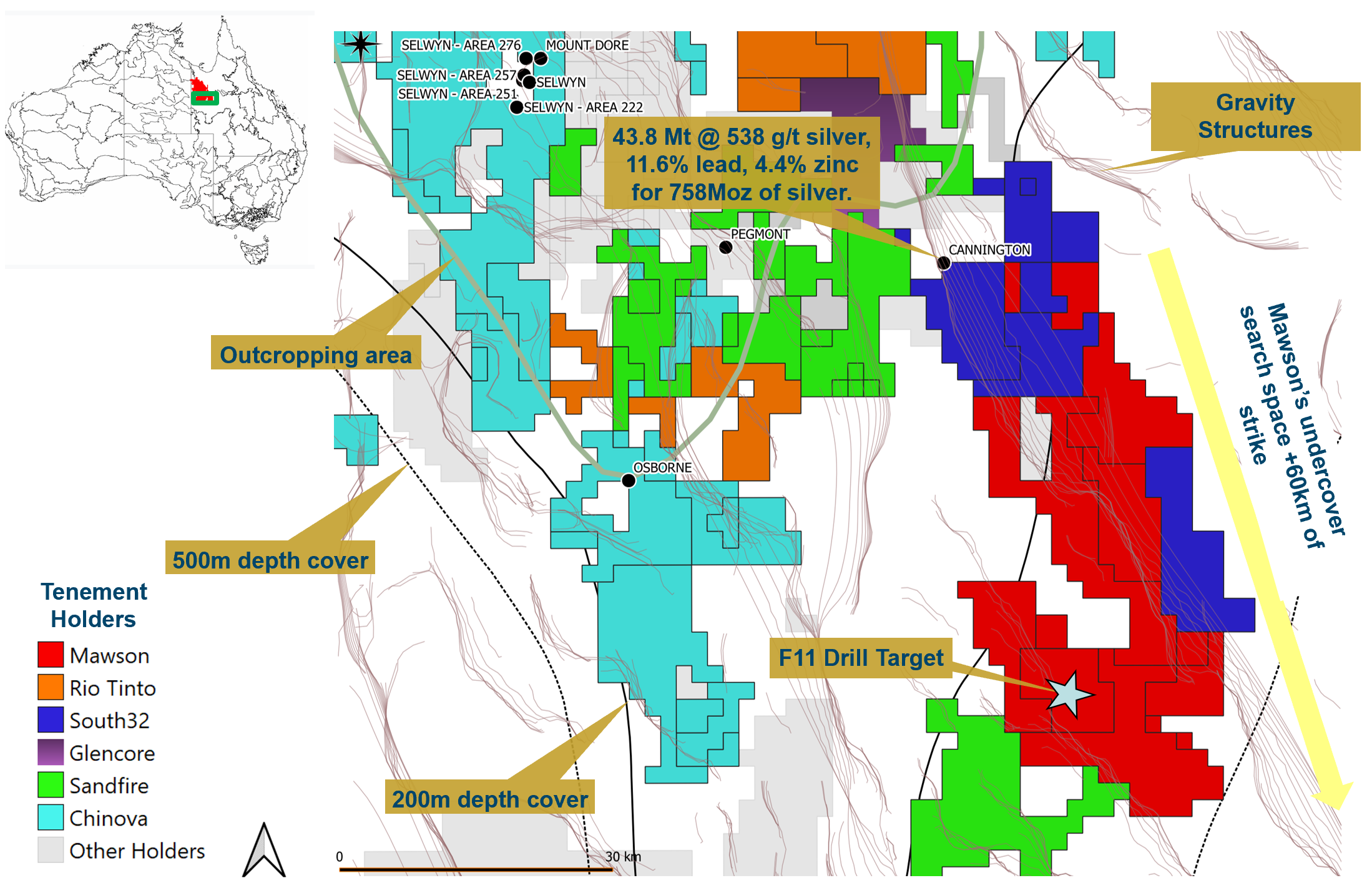
VANCOUVER, BC / ACCESSWIRE / March 4, 2021 / Mawson Gold Limited ("Mawson" or the "Company") (TSX:MAW)(FSE:MXR)(OTC PINK:MWSNF) announces the return of assays from the drilling of the F11 target 50 kilometres to the south of Cannington silver-zinc-lead mine in the Mount Isa block (Figure 1). Drill funding was supported by an AUD

Key points:
- The drill hole targeted a combined gravity and magnetic anomaly below 318 metres of Mesozoic cover rocks;
- Thirty-seven assay samples were taken in sulphidic intervals and zones of brittle chlorite-bearing alteration;
- Nine of the twenty samples below 750 metres ranged between 61 ppm and 8,660 ppm and averaged 1,202 ppm copper associated with texturally late sulphidic hydrothermal alteration;
- Samples from a 43 metre wide zone of brittle faults, fractures and cataclastic zones with pyrite-sericite-chlorite-graphite as the dominant alteration are weakly anomalous in base and precious metals and will be the subject of further investigation in 2021
Mr. Hudson, Chairman and CEO, states: "Anomalous copper is always encouraging, and the results of this drill hole reinforce the strong prospectivity of the Eastern Succession in the Mount Isa Block with this, the only drill hole, to be ever drilled into basement rocks within a 10 kilometre radius. Mawson will further examine the drilling results, in particular the lower 100 metres of the drill core, and work it back into our newly collected (2019) gravity and magnetic datasets to develop further targets."
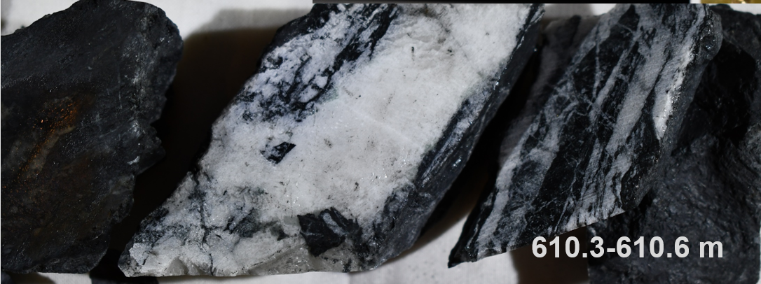
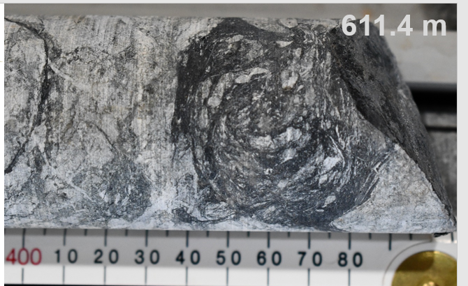
The drill hole (MQDDH001; Table 1 for collar information) was completed in October 2020 and drilled to 849.7 metres with basement rocks intersected at 318 metres. Based on results of Mawson's gravity and magnetic surveys, the target source was modelled below the basement-cover contact within amphibolite facies metamorphic rocks to test a coherent and large undrilled multi-point 1.95 mgal residual gravity anomaly with an adjacent magnetic high. The anomaly has a shallow peak of 700 metres depth and average depth of 1,000-1,500 metres. Iron oxide copper-gold (IOCG) and Broken Hill-type silver-lead-zinc systems are the main target styles within Mawson's Isa Southeast Project. The pyritic carbonaceous fault zone intersected is possibly an extension of the regionally significant Cloncurry Fault (see photos 1 & 2).
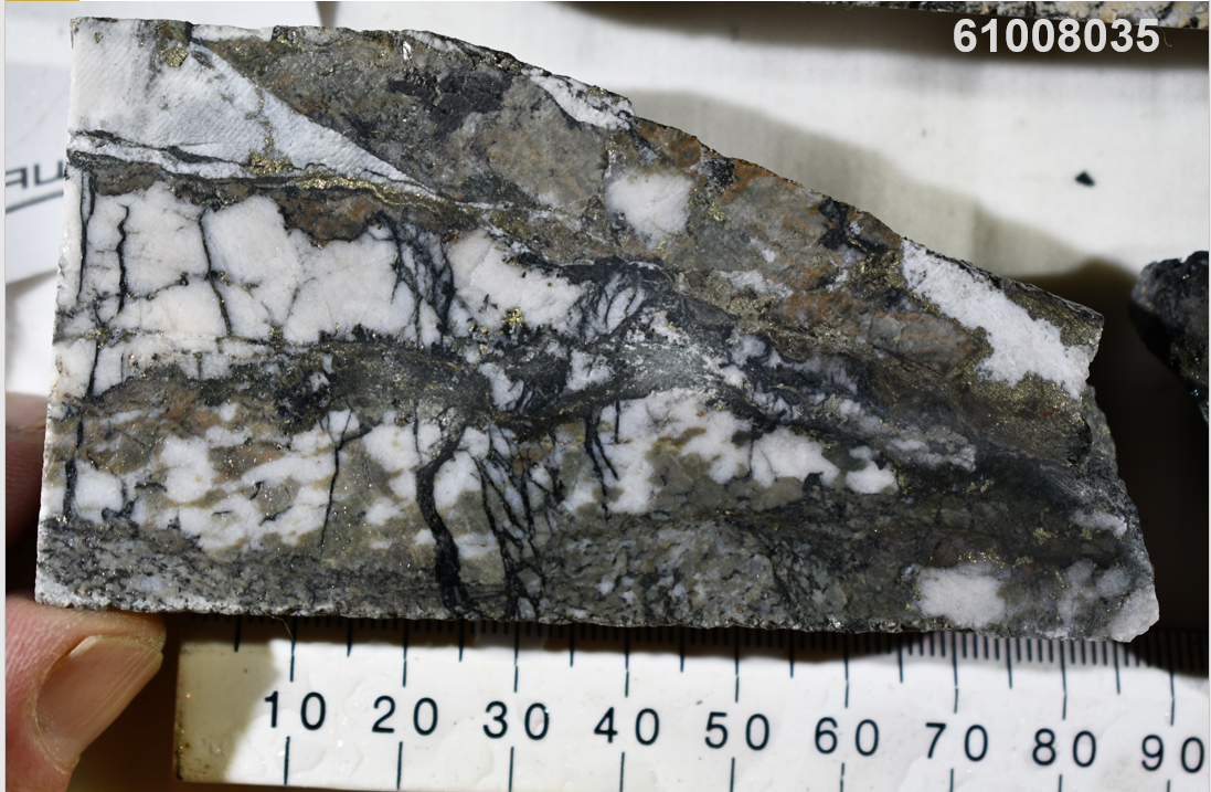
The lower part of the drill hole below 750 metres contains most of the sulphides of interest, in particular pyrrhotite-rich zones with veinlets and disseminated chalcopyrite hosted by potassic-altered metasediments and mafic rocks. It is within these zones that the anomalous copper, arsenic, silver and zinc occur (Tables 2 & 3). From 750 to 838.8 metres downhole, 20 selective samples, representing 12.7 metres of drill core assayed from 61 ppm - 8,660 ppm and averaged 1,202 ppm copper, 0.02 ppm - 0.70 ppm and averaged 0.27 ppm silver and 31.7 ppm - 237 ppm and averaged 109 ppm zinc. Gold results were low with a maximum value of 20 ppb. The increase in copper and associated elements lower in the drill hole and the strong correlation with the emplacement and sulphidic alteration of pegmatites is an encouraging sign for development of further mineralization in the area. Texturally late sulphide enrichment and/or mobilization is a feature of mineralization styles in the Eastern Succession, largely driven by fluids derived from the Williams-Naraku igneous suite (for example photos 3 & 4).
A project in conjunction with James Cook University will be conducted in 2021 to compare MQDDH001 results with other Mount Isa Eastern Succession mineral systems. These results will be integrated with our newly collected (2019) gravity and magnetic datasets across Mawson's Southeast Mt Isa project exploration permits to develop new drill targets.
Technical Background
Drill hole collar coordinates are shown in Table 1 and selected assay results in Table 2. Representative photographs are shown in Photos 1-4 (the same photos as reported in Mawson press release of December 07, 2020). The true thickness of the mineralized interval is interpreted to be approximately
Qualified Person
Dr. Nick Cook (FAusIMM), Chief Geologist for the Company, is a qualified person as defined by National Instrument 43-101 - Standards of Disclosure or Mineral Projects and has prepared or reviewed the preparation of the scientific and technical information in this press release.
About Mawson Gold Limited (TSX:MAW)(FSE:MXR)(OTC PINK:MWSNF)
Mawson Gold Limited is an exploration and development company. Mawson has distinguished itself as a leading Nordic Arctic exploration company with a focus on the flagship Rajapalot gold-cobalt project in Finland. The Mount Isa exploration permits and the Victorian project acquisition provides Mawson with a strategic and diversified portfolio of high-quality gold exploration assets in two safe jurisdictions.
On behalf of the Board,
"Michael Hudson"
Michael Hudson, Chairman & CEO
Further Information
www.mawsongold.com
1305 - 1090 West Georgia St.
Vancouver, BC, V6E 3V7
Mariana Bermudez (Canada), Corporate Secretary
+1 (604) 685 9316
info@mawsongold.com
Forward-Looking Statement
This news release contains forward-looking statements or forward-looking information within the meaning of applicable securities laws (collectively, "forward-looking statements"). All statements herein, other than statements of historical fact, are forward-looking statements. Although Mawson believes that such statements are reasonable, it can give no assurance that such expectations will prove to be correct. Forward-looking statements are typically identified by words such as: believe, expect, anticipate, intend, estimate, postulate, and similar expressions, or are those, which, by their nature, refer to future events. Mawson cautions investors that any forward-looking statements are not guarantees of future results or performance, and that actual results may differ materially from those in forward-looking statements as a result of various factors, including, but not limited to, capital and other costs varying significantly from estimates, changes in world metal markets, changes in equity markets, the potential impact of epidemics, pandemics or other public health crises, including the current pandemic known as COVID-19 on the Company's business, planned drill programs and results varying from expectations, delays in obtaining results, equipment failure, unexpected geological conditions, local community relations, dealings with non-governmental organizations, delays in operations due to permit grants, environmental and safety risks, and other risks and uncertainties disclosed under the heading "Risk Factors" in Mawson's most recent Annual Information Form filed on www.sedar.com. Any forward-looking statement speaks only as of the date on which it is made and, except as may be required by applicable securities laws, Mawson disclaims any intent or obligation to update any forward-looking statement, whether as a result of new information, future events or results or otherwise.
Table 1: Collar Information for drill hole MQDDH001 at Southeast Isa Project (Coordinate system GDA94, Zone54).
HoleID | East | North | RL | Dip | Az | Depth (m) | Permit | Comment |
MQDDH001 | 505762 | 7535004 | -75 | 270 | 849.7 | EL26940 | Target based on inversion of ground gravity and airborne magnetic data |
Table 2: Assay results from MQDDH001 showing a selection of elements.
From | To | Width | Sample | Notes | Cu ppm | Zn ppm | S % | Au_ppm | Ag_ppm | As_ppm |
408 | 414 | 6 | 61008042 | qtz-fsp-bi-musc - chips | 85 | 39.1 | 0.3 | <0.01 | 0.069 | 3.7 |
414 | 420 | 6 | 61008043 | qtz-fsp-bi-musc - chips | 36.3 | 40.7 | 0.18 | <0.01 | 0.041 | 2.7 |
436.4 | 436.75 | 0.35 | 61008001 | Schlieren granite | 118.5 | 29.4 | 0.24 | <0.01 | 0.05 | 1.9 |
437.1 | 437.4 | 0.3 | 61008002 | Amphibolite | 157 | 70.9 | 0.25 | 0.01 | 0.027 | 12.6 |
467.6 | 468 | 0.4 | 61008003 | Amphibolite | 109 | 141 | 0.11 | 0.01 | 0.108 | 1.1 |
500.95 | 501.45 | 0.5 | 61008004 | schlieren-bearing peg/granite | 9.51 | 46.3 | 0.03 | 0.01 | 0.019 | 0.5 |
552.6 | 552.9 | 0.3 | 61008005 | sheared sericitic chloritic fault rock | 14.9 | 68 | 0.06 | 0.01 | 0.02 | 0.4 |
567.2 | 567.5 | 0.3 | 61008006 | Granite | 10.6 | 15.5 | 0.02 | <0.01 | 0.007 | 0.3 |
568.2 | 568.3 | 0.1 | 61008007 | pyritic psammitic granoblastic texture | 33.1 | 47.7 | 0.14 | 0.01 | 0.014 | 0.3 |
608.7 | 609.1 | 0.4 | 61008008 | ?altered and pyritic fractured ?metased? | 98.7 | 8.1 | 0.19 | 0.02 | 0.027 | 0.3 |
610.3 | 610.6 | 0.3 | 61008009 | graphitic cataclasite (pyritic) | 208 | 300 | 0.84 | 0.01 | 0.1 | 3.2 |
623.85 | 624.15 | 0.3 | 61008012 | Probable amphibolite - py + po | 561 | 120 | 2.22 | <0.01 | 0.145 | 12.2 |
642.15 | 642.45 | 0.3 | 61008013 | pyritic psammite | 245 | 147.5 | 3.94 | 0.01 | 0.342 | 1.5 |
644.7 | 645.15 | 0.45 | 61008014 | pyritic psammite, possibly with other metallic mineral | 335 | 210 | 3.32 | 0.02 | 0.171 | 1.3 |
648.6 | 649.4 | 0.8 | 61008015 | sulphide and ser-chl pegmatite | 326 | 17.2 | 1.1 | 0.02 | 0.039 | 0.6 |
657.9 | 658.5 | 0.6 | 61008017 | Amphibolite with sulphide - peg margin | 147.5 | 139.5 | 0.84 | <0.01 | 0.032 | 0.5 |
665.95 | 666.2 | 0.25 | 61008018 | graphitic psammopelite with py, ?chl, trace ccp | 478 | 28.9 | 1.58 | <0.01 | 0.119 | 1.1 |
752.7 | 753.5 | 0.8 | 61008020 | chl altered and sulphide-rich amph | 1885 | 103.5 | 9.92 | <0.01 | 0.533 | 16.7 |
753.5 | 754.15 | 0.65 | 61008021 | chl altered and sulphide-rich amph | 1660 | 138.5 | 3.98 | 0.01 | 0.388 | 4.2 |
755.35 | 756.2 | 0.85 | 61008022 | pegmatite and altered amph margin - sulphidic | 2340 | 173 | 8.02 | 0.01 | 0.684 | 14.2 |
758.9 | 759.6 | 0.7 | 61008040 | sulphidic psammite + peg | 1095 | 115 | 2.4 | <0.01 | 0.151 | 6.6 |
759.6 | 759.9 | 0.3 | 61008041 | po - qtz - fspar cp pegmatite | 8660 | 115 | 9.79 | 0.01 | 0.703 | 5.8 |
773 | 774 | 1 | 61008023 | sulphidic psammite | 442 | 113 | 2.43 | 0.01 | 0.086 | 0.9 |
774 | 775 | 1 | 61008024 | sulphidic psammite | 328 | 132.5 | 2.09 | <0.01 | 0.089 | 2.2 |
775 | 776 | 1 | 61008025 | sulphidic psammite | 335 | 76 | 1.25 | 0.02 | 0.226 | 2.4 |
781.5 | 781.8 | 0.3 | 61008026 | chl-py altered pegmatite | 713 | 35 | 1.14 | <0.01 | 0.151 | 0.9 |
789 | 789.4 | 0.4 | 61008039 | ?K-feldspar altered amphibolite | 276 | 237 | 0.33 | <0.01 | 0.063 | 1 |
793 | 793.45 | 0.45 | 61008027 | altered (chl) pyritic amph | 1090 | 85.8 | 4.81 | 0.01 | 0.27 | 0.8 |
795.4 | 796 | 0.6 | 61008028 | altered (chl) pyritic amph | 481 | 145.5 | 1.4 | <0.01 | 0.114 | 1.5 |
814 | 814.7 | 0.7 | 61008030 | qtz-po zone in amph | 849 | 54.2 | 18.35 | 0.01 | 0.354 | 2.5 |
816.4 | 816.9 | 0.5 | 61008031 | py-bearing edge amph grading into faulted/cataclasite zone | 305 | 152 | 1.25 | <0.01 | 0.159 | 2.8 |
817 | 817.5 | 0.5 | 61008032 | cataclastic & broken amph margin | 132 | 77.8 | 0.58 | <0.01 | 0.135 | 1.6 |
823.8 | 824.15 | 0.35 | 61008038 | sulphide-bearing psammite + unk metallic mineral | 449 | 50.4 | 1.6 | 0.01 | 0.238 | 3.3 |
829 | 830 | 1 | 61008033 | sulphidic retrogressed pegmatite | 404 | 34 | 1.55 | <0.01 | 0.133 | 1 |
830 | 831 | 1 | 61008034 | sulphidic retrogressed pegmatite | 354 | 31.7 | 1.28 | <0.01 | 0.103 | 0.7 |
832.1 | 832.5 | 0.4 | 61008035 | sulphidic retrogressed pegmatite | 2190 | 124 | 2.77 | <0.01 | 0.702 | 0.5 |
838.6 | 838.8 | 0.2 | 61008036 | sill-bi pelite | 61.1 | 183 | 0.13 | <0.01 | 0.018 | 55.6 |
Table 3: Basic statistics of assay results from Table 2
Depth | Statistics | Cu ppm | Zn ppm | S % | Au_ppm | Ag_ppm | As_ppm |
from 408 m - 666.2 m | max | 561.0 | 300.0 | 3.9 | 0.0 | 0.3 | 12.6 |
min | 9.5 | 8.1 | 0.0 | 0.0 | 0.0 | 0.3 | |
average | 174.9 | 86.5 | 0.9 | 0.0 | 0.1 | 2.6 | |
count | 17 | 17 | 17 | 10 | 17 | 17 | |
drill metres sampled | 30.3 | ||||||
from 752.7 m - 838.8 m | max | 8660.0 | 237.0 | 18.4 | 0.02 | 0.70 | 55.6 |
min | 61.1 | 31.7 | 0.1 | 0.01 | 0.02 | 0.5 | |
average | 1202.5 | 108.8 | 3.8 | 0.01 | 0.27 | 6.3 | |
count | 20 | 20 | 20 | 8 | 20.00 | 20 | |
drill metres sampled | 12.7 |
|Figure 1: Map of the Mount Isa SE project showing exploration permits, other tenement holders, limit to outcropping area, gravity structures and the location of the F11 drill target.


Photo 1: Quartz-carbonate-chlorite-graphite veined within zone of sericite-pyrite-chlorite alteration (from sample interval 610.3-610.6 metres).

Photo 2: Rotated cataclastic "ball" comprising chlorite, graphite, quartz and carbonate from within broad faulted and veined zone of sericite-pyrite-chlorite alteration (611.4 metres).

Photo 3: Abundant pyrrhotite and quartz with trace chalcopyrite and pyrite associated with chlorite-pyrite-quartz shear (left side of core; from sample interval 814.0-814.7 metres; 0.085 wt % Cu).

Photo 4: Fracture-controlled biotite-sericite-pyrite alteration with trace chalcopyrite associated with quartz-carbonate veining from sample interval 832.1-832.5 metres (0.22 wt % Cu).
SOURCE: Mawson Gold Limited
View source version on accesswire.com:
https://www.accesswire.com/633395/Mawson-Reports-Drill-Results-From-F11-Target-South-East-Mount-Isa-Project


