Maxar’s High-Resolution Vivid Basemaps Enhances Esri ArcGIS Living Atlas of the World
Maxar Technologies (NYSE:MAXR) announced a multiyear agreement with Esri to enhance the World Imagery layer with its Vivid basemaps in the Living Atlas. This upgrade will boost the resolution of nearly half the global landmass from 1.2 m to 60 cm. Maxar has become the largest provider of satellite imagery for Esri, supplying quarterly updates to keep imagery current. Esri users will benefit from improved mapping and data analysis capabilities. This partnership underscores the significance of high-quality geospatial data in various applications.
- Enhanced agreement with Esri to improve World Imagery layer resolution.
- Resolution upgrade from 1.2 m to 60 cm for nearly half the global landmass.
- Maxar is the largest provider of satellite imagery for Esri's Living Atlas.
- None.

The
With the new, multiyear agreement, Esri will use Maxar’s Vivid basemaps to upgrade nearly half of the global landmass in Living Atlas from 1.2 m resolution to 60 cm resolution. This enhancement reflects a continued investment from the Esri Living Atlas team to bring the best quality, highest resolution imagery basemaps to ArcGIS Online users for creating more accurate maps and making better decisions.
Esri’s Living Atlas is a collection of geographic information from around the globe, including maps, apps and data layers. ArcGIS users around the globe rely on the Living Atlas daily to create new derivative maps and data layers, to conduct environmental studies, and to build dashboards for tracking pandemics, among many other use cases.
“Maxar is proud to continue to license Vivid as the foundational data for the Living Atlas, which is used by so many organizations around the world,” said
Over the past decade,
“Esri’s ArcGIS system is more powerful for end users with Maxar’s satellite imagery serving as foundational data in Esri’s World Imagery offerings,” said
These
-
Vivid Standard is a high-resolution, high-accuracy and visually-consistent global imagery basemaps built with
Maxar satellite imagery. - Vivid Advanced upgrades Vivid Standard’s quality over select metropolitan areas with nearly cloud-free imagery basemaps.
- NaturalVue® 2.0 is an image mosaic that combines more than 60,000 Landsat 8 images to create a seamless, virtually cloud-free, 15 meter basemap that reflects the Earth’s true colors.
- National Urban Change Indicator (NUCI) is a commercial urban change detection product that highlights areas of new construction activity by isolating changes that persist over time, derived from more than 13,000 Landsat images.
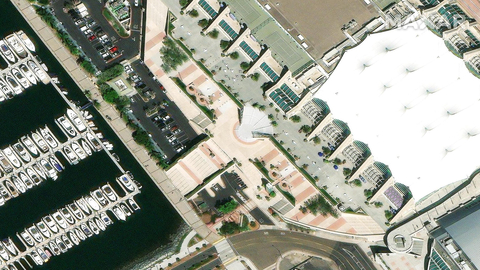
A Vivid Standard sample of
About
About Esri
Esri, the global market leader in geographic information system (GIS) software, location intelligence, and mapping, helps customers unlock the full potential of data to improve operational and business results. Founded in 1969 in
Forward-Looking Statements
This press release may contain forward-looking statements that reflect management's current expectations, assumptions and estimates of future performance and economic conditions. Any such forward-looking statements are made in reliance upon the safe harbor provisions of Section 27A of the Securities Act of 1933 and Section 21E of the Securities Exchange Act of 1934. The Company cautions investors that any forward-looking statements are subject to risks and uncertainties that may cause actual results and future trends to differ materially from those matters expressed in or implied by such forward-looking statements, including those included in the Company’s filings with
View source version on businesswire.com: https://www.businesswire.com/news/home/20220721005266/en/
Investor Relations Contact:
Maxar Investor Relations
1-303-684-5543
jonny.bell@maxar.com
Media Contact:
Maxar Media Relations
1-303-684-4352
kristin.carringer@maxar.com
Source:
FAQ
What is the new agreement between Maxar and Esri about?
How will the new basemaps from Maxar affect users?
What resolution upgrade is being implemented in the Living Atlas?
How often will Maxar update the imagery for Esri?


