Fosterville South Expands Walhalla Gold Belt Project Footprint After Fieldwork Identifies Multiple As-Sb Epizonal Anomalies
Fosterville South Exploration Ltd. (FSXLF) reported results from a soil sampling program across the Enoch's Point and Reedy Creek goldfields, identifying five As-Sb epizonal anomalies that indicate potential gold mineralization. The company is expanding its Walhalla Gold Belt Project by applying for two new tenements, totaling 218 km², providing a continuous strike of approximately 72 km. With over $25 million in cash, Fosterville South is well-positioned for ongoing exploration, including high-priority drilling targets in Enoch's Point and Reedy Creek.
- Identification of five significant As-Sb epizonal anomalies indicating potential gold mineralization.
- Expansion of Walhalla Gold Belt Project footprint with new tenement applications covering 218 km².
- Strong financial position with over $25 million in cash for exploration activities.
- None.
Insights
Analyzing...
VANCOUVER, BC, May 20, 2021 /PRNewswire/ - Fosterville South Exploration Ltd. ("Fosterville South") or (the "Company") (TSXV: FSX) (OTC: FSXLF) (Germany: 4TU) is pleased to report the results of a soil sampling program at Enoch's Point goldfield (Walhalla Gold Belt Project) and Reedy Creek goldfield (Providence Gold Project) that has detected five significant As-Sb epizonal anomalies. Soil sampling and assaying in the areas are ongoing.
Epizonal gold mineralised systems have arsenic-antimony mineralisation haloes that are used as trace element pathfinders, such that the larger the halo then the larger the potential gold mineralization.
Based on the location of some of these anomalies, the Company has been recently active in the area strategically expanding the footprint of the land package and through its wholly owned subsidiary Currawong Resources, has increased the size of its Walhalla Gold Belt Project by filing two additional tenement applications totalling 218km2. These new tenement applications border the Enoch's Point, Harbinger and Pinnacles tenements. The company now holds contiguous tenements and tenement applications covering approximately 72km of strike in the western and central parts of the Walhalla Gold Belt.
Enoch's Point
The Enoch's Point project covers 290km2 of highly prospective ground within the Woods Point – Walhalla Gold Belt, with numerous gold prospects. The latest soil sampling program has generated three extensive As±Sb epizonal anomalies within this area:
- The Dray Track arsenic anomaly that is approximately 1 km by 1 km.
- The Big River Sb prospect to Hope Track anomaly that is approximately 3.2 km by 600 m
- The Londonderry Reef that is approximately 1.6 km in length and up to 100 m wide.
Dray Track Prospect. The Big River Sb Prospect is hosted by Siluro-Devonian folded and faulted sediments and occurs near the Eildon Thrust Fault, which is west bounding structure of the Enoch's Point Thrust Fault Zone. Reconnaissance regional soil sampling traverses discovered an pXRF arsenic anomalous zone outlining an area approximately 1km in diameter, with some outcrops of pyritic quartz stockwork veining in sandstone. Gold assays for these soil samples are pending.
Big River Sb Prospect to Hope Track. The Big River Sb Prospect is hosted by Siluro-Devonian folded and faulted sediments and occurs in close proximity to the Jerusalem Inlet Fault, which is part of the Enoch's Point Thrust Fault Zone. This fault zone extends for tens of kilometers north to south across the entire state of Victoria. A soil program was conducted at the Big River Antimony Mine, which has outlined an area of As-Sb pXRF soil anomalism covering strike length of 1km by 600m width and possibly extending 1.6km south to the Hope Track arsenic anomalous traverse, as well as north to another ridge traverse making an overall strike extent of 3.2km and up to 600m wide. Mineralisation is therefore open along strike in both north and south directions beyond these two remote traverses. Fosterville South is exploring the intervening ground currently to establish mineralisation continuity. Gold assays for these soil samples are pending.
Londonderry Reef. The Londonderry gold prospect is hosted by the Devonian Norton Gully Sandstone and historic gold production is from mineralised quartz stockwork sandstone and diorite dykes. Grid based sampling results determined that anomalous arsenic soil samples occur for a 1.6 km strike length and remains open north and south. Previous rock chip results had reported grades of up to 179 g/t Au (see Fosterville South News Release March 17, 2021).
Wild Dog Ring Dyke. The Wild Dog Ring Dyke consists of granite and almandine-bearing granodiorite porphyry. This porphyry contains antimony-gold in sheeted quartz chlorite and carbonate veins, with sericite alteration haloes. Within the Enoch's Point licence, the dyke extends for 23km and is variably Au-As-Sb mineralised for its entire length. BHP drilled two holes in the south in 1985 and CRAE drilled two holes in the central part in 1994. All holes are less than 136m depth. Previous explorers soil sampling traverses indicate numerous gold mineralised prospects occur which require follow up in this very prospective structure.
Reedy Creek
The Reedy Creek goldfield forms part of the Providence Project in the Melbourne Zone of Central Victoria west of the Walhalla Gold Belt. The goldfield is hosted by the Silurian Dargile Formation of siltstone and sandstone set in a northwest striking doubly plunging anticlinal dome. This geological setting is similar to the Costerfield dome which is being mined by Mandalay Resources and is currently one of the highest-grade gold mines in the world. The Reedy Creek goldfield is well known for its high-grade historic gold production. This goldfield that has never been previously explored or drilled by modern techniques. Soil sampling has generated various areas of mineralisation and exploration is ongoing, both as infill sampling and in the neighbouring landowner properties. The latest sampling program has identified two extensive As-Sb epizonal anomalies:
- The Prince of Wales Reef and satellite mineralisation extends 1.6 km by 440 m.
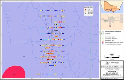
- Big Ben prospect area soil anomalies extend over the entire 2km grid.
Prince of Wales Reef. A north-northwest striking pXRF arsenic anomalous trend is present and associated with the 600m long Prince of Wales reef, which was worked by several gold mining companies in the late 1800s. Further east there is a parallel arsenic trend that shows quartz veining. This secondary area of potential mineralization has had no historical mining. The soil geochemical anomalies are open along strike in both directions and landowner access is being or has been secured. Historic gold workings extend for a further 2.5km southeast of the soil grid and 3km northwest of the soil grid on various mined structures within the overall corridor.
Big Ben Prospect. The Big Ben prospect area is hosted by Devonian Humevale Siltstone and occurs partly within the contact metamorphic aureole of the Mount Robertson granodiorite intrusion. Various Au-As mineralised structures occur within the prospect including those associated with the Harry's Dyke and Big Ben gold workings. The main continuous Au-As anomaly lies in the southwest of the grid and is at least 600m in strike length and up to 120m wide. Soil sampling has covered an area of 2000m by 800m and soil sampling is ongoing. Further gold assay results are pending for the newly acquired soil samples.
Rex Motton states "These extensive As-Sb epizonal soil anomalies contain significant strike length and may indicate various robust gold systems through a number of our properties. Each of Enoch's Point and Reedy Creek are high-priority target areas for future drilling by FSX".
Fosterville South is very active in its exploration of a host of its highest value targets in the largest prospective package in Victoria and has now moved into an expanded operations headquarters in Bendigo, Australia. Expanded field teams, drill rigs and geologists are accelerating the activity throughout the tenements. With in excess of
In addition to regional fieldwork, such as described in today's News Release, the company has ongoing active exploration programs, including drilling at the Lauriston, Moormbool and Golden Mountain projects.
Quality Assurance / Quality Control
All portable XRF arsenic and antimony assays of the collected soil samples are conducted by Currawong Resources staff, which includes regular duplicates, blanks and supplied instrument standards with the expected results from the samples submitted. The quality control results are consistent. Sampling has been done in several campaigns and follow up results have been supportive of previous results.
The gold assays were subject to quality control measures appropriate for reconnaissance rock chip sampling with duplicates, blanks and commercially available standards with the expected results from the samples submitted. All assays were conducted by Onsite Laboratory Services Ltd (ISO: 9001), located in Bendigo, Victoria, using fire assay techniques with a 50g charge and AAS finish. The quality control results are consistent.
About Fosterville South Exploration Ltd.
Fosterville South began with two,
All of Fosterville South's properties, with the possible exception of Moormbool, have had historical gold production from hard rock sources despite limited modern exploration and drilling.
Qualified Person
The technical content of this news release has been reviewed, verified and approved by Rex Motton, AusIMM (CP), COO and Director of Fosterville South, a qualified person as defined by NI 43-101. Historical records were verified by reviewing annual and quarterly reports from government records by the Qualified Person.
On behalf of the Company
Rex Motton
Chief Operating Officer and Director
Forward-Looking Statements
Information set forth in this news release contains forward-looking statements that are based on assumptions as of the date of this news release. These statements reflect management's current estimates, beliefs, intentions and expectations. They are not guarantees of future performance. Fosterville South cautions that all forward looking statements are inherently uncertain and that actual performance may be affected by many material factors, many of which are beyond their respective control. Such factors include, among other things: risks and uncertainties relating to Fosterville South's limited operating history, its exploration and development activities on is Lauriston and Golden Mountain Properties and the need to comply with environmental and governmental regulations. Accordingly, actual and future events, conditions and results may differ materially from the estimates, beliefs, intentions and expectations expressed or implied in the forward-looking information. Except as required under applicable securities legislation, Fosterville South does not undertake to publicly update or revise forward-looking information.
Neither TSX Venture Exchange nor its Regulation Services Provider (as that term is defined in the policies of the Exchange) accepts responsibility for the adequacy or accuracy of this release.
![]() View original content to download multimedia:http://www.prnewswire.com/news-releases/fosterville-south-expands-walhalla-gold-belt-project-footprint-after-fieldwork-identifies-multiple-as-sb-epizonal-anomalies-301295744.html
View original content to download multimedia:http://www.prnewswire.com/news-releases/fosterville-south-expands-walhalla-gold-belt-project-footprint-after-fieldwork-identifies-multiple-as-sb-epizonal-anomalies-301295744.html
SOURCE Fosterville South Exploration Ltd.


